
Spenden
Topografische Karte Phagwara Tahsil
Klicken Sie auf die Karte, um die Höhe anzuzeigen.
Spenden
Über diese Karte
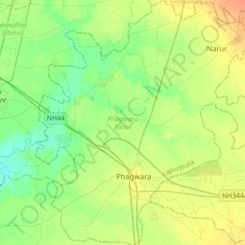
Name: Topografische Karte Phagwara Tahsil, Höhe, Relief.
Ort: Phagwara Tahsil, Kapurthala, Punjab, India (31.15997 75.67041 31.37399 75.91025)
Durchschnittliche Höhe: 241 m
Minimale Höhe: 229 m
Maximale Höhe: 258 m
Spenden
Andere topografische Karten
Klicken Sie auf eine Karte, um ihre Topografie, ihre Höhe und ihr Relief anzuzeigen.
Dasuya
India > Punjab > Dasua Tahsil
Dasuya is located in Hoshiarpur district of Punjab state in India. at 31°49′N 75°40′E / 31.82°N 75.66°E / 31.82; 75.66. It has an average elevation of 239 metres (784 ft) from sea level.
Durchschnittliche Höhe: 254 m
Bathinda
India > Punjab > Bathinda Tahsil
Bathinda is in the northwestern region of India and is a part of the Indo-Gangetic alluvial plains. The exact cartographic co-ordinates of Bathinda are 30°12′N 74°57′E / 30.20°N 74.95°E / 30.20; 74.95. It has an average elevation of 201 metres (660 ft).
Durchschnittliche Höhe: 208 m
Spenden
Spenden
Spenden
Spenden
Spenden
Spenden
Spenden
Spenden
Spenden
Spenden
Spenden
Nabha
India > Punjab > Nabha Tahsil
Nabha is located at 30°22′N 76°09′E / 30.37°N 76.15°E / 30.37; 76.15. It has an average elevation of 246 metres (807 feet).
Durchschnittliche Höhe: 251 m
Spenden
Spenden
Faridkot
India > Punjab > Faridkot Tahsil
The average elevation is 196 metres (643 ft). The town is located on the Punjab Plains, which in a macro regional context forms a part of greater Satluj Ganga plain. It is a low-lying flat area. The surface of the district is depositional plain which was formed by alleviation by the rivers flowing in these…
Durchschnittliche Höhe: 204 m
Spenden
Spenden
Spenden
Spenden
Amritsar
India > Punjab > Amritsar I Tahsil
Amritsar is located at 31°38′N 74°52′E / 31.63°N 74.87°E / 31.63; 74.87 with an average elevation of 234 metres (768 ft) in the Majha region of the state of Punjab in North India and lies about 15 miles (24 km) east of the border with Pakistan. Administrative towns includes Ajnala, Attari,…
Durchschnittliche Höhe: 231 m
Spenden
Spenden
Sahibzada Ajit Singh Nagar
India > Punjab > S.A.S. Nagar (Mohali) Tahsil
Durchschnittliche Höhe: 318 m
Spenden
Ludhiana
India > Punjab > Ludhiana (West) Tahsil
Ludhiana is located at 30°54′N 75°51′E / 30.9°N 75.85°E / 30.9; 75.85. It has an average elevation of 244 metres (801 ft). Ludhiana City, to its residents, consists of the Old City and the New City. The new city primarily consists of the Civil Lines area which was historically known as the…
Durchschnittliche Höhe: 247 m
Spenden
Spenden
Spenden
Rupnagar
India > Punjab > Rupnagar Tahsil
Rupnagar is located at 30°58′N 76°32′E / 30.97°N 76.53°E / 30.97; 76.53. It has an average elevation of 260 metres (850 ft). The town lies on the bank of Satluj River and the Shivalik hill range spreads along the opposite bank of the river.
Durchschnittliche Höhe: 281 m
Spenden
Spenden