Geolokalisieren
👉 Easily get elevation data in JSON, GeoTIFF and KML formats using Elevation API
Vielen Dank für die Unterstützung dieser Website ❤️
Spenden

Topografische Karte Bathinda

Klicken Sie auf die Karte, um die Höhe anzuzeigen.

👉 Easily get elevation data in JSON, GeoTIFF and KML formats using Elevation API
Vielen Dank für die Unterstützung dieser Website ❤️
Spenden

Bathinda

Bathinda is in the northwestern region of India and is a part of the Indo-Gangetic alluvial plains. The exact cartographic co-ordinates of Bathinda are 30°12′N 74°57′E / 30.20°N 74.95°E / 30.20; 74.95. It has an average elevation of 201 metres (660 ft).

Wikipedia (CC-BY-SA 3.0)

👉 Easily get elevation data in JSON, GeoTIFF and KML formats using Elevation API
Vielen Dank für die Unterstützung dieser Website ❤️
Spenden

Über diese Karte

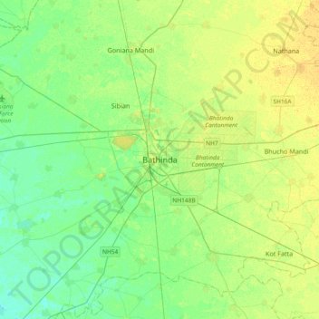
Name: Topografische Karte Bathinda, Höhe, Relief.

Ort: Bathinda, Bathinda Tahsil, Bathinda, Punjab, 151001, India (30.04679 74.78637 30.36679 75.10637)

Durchschnittliche Höhe: 208 m

Minimale Höhe: 199 m

Maximale Höhe: 218 m

👉 Easily get elevation data in JSON, GeoTIFF and KML formats using Elevation API
Vielen Dank für die Unterstützung dieser Website ❤️
Spenden