
Topografische Karte San Juan
Interaktive Karte
Klicken Sie auf die Karte, um die Höhe anzuzeigen.
San Juan
"San Juan City" is a contraction of the city's traditional name of "San Juan del Monte" (lit. Saint John of the Mountain). As with numerous other places in the Philippines, the name combines a patron saint and a toponym; in this case Saint John the Baptist with the locale's hilly terrain and relatively higher elevation compared to surrounding areas.
Über diese Karte
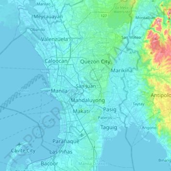
Name: Topografische Karte San Juan, Höhe, Relief.
Durchschnittliche Höhe: 35 m
Minimale Höhe: -3 m
Maximale Höhe: 480 m
Andere topografische Karten
Klicken Sie auf eine Karte, um ihre Topografie, ihre Höhe und ihr Relief anzuzeigen.
Greenhills
Greenhills and the adjacent West Crame are the only barangays in San Juan that are not entirely situated on tuff and tuffaceous sedimentary rock, with parts of the barangay being situated on top of pyroclastic flow adobe deposits. The highest elevation of San Juan can be found in Greenhills at its border with…
Durchschnittliche Höhe: 32 m