
Vielen Dank für die Unterstützung dieser Website ❤️
Spenden
Spenden
Topografische Karte Greenhills
Klicken Sie auf die Karte, um die Höhe anzuzeigen.
Vielen Dank für die Unterstützung dieser Website ❤️
Spenden
Spenden
Greenhills
Greenhills and the adjacent West Crame are the only barangays in San Juan that are not entirely situated on tuff and tuffaceous sedimentary rock, with parts of the barangay being situated on top of pyroclastic flow adobe deposits. The highest elevation of San Juan can be found in Greenhills at its border with Quezon City's Barangay Camp Aguinaldo along EDSA, peaking at 34 meters (112 ft) above sea level.
Vielen Dank für die Unterstützung dieser Website ❤️
Spenden
Spenden
Über diese Karte
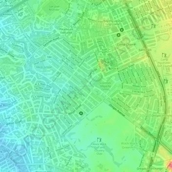
Name: Topografische Karte Greenhills, Höhe, Relief.
Durchschnittliche Höhe: 32 m
Minimale Höhe: 8 m
Maximale Höhe: 61 m
Vielen Dank für die Unterstützung dieser Website ❤️
Spenden
Spenden