
Topografische Karte Quezon
Klicken Sie auf die Karte, um die Höhe anzuzeigen.
Quezon
The physiography of the municipality falls into two basic categories: an alluvial plain and a mountainous terrain. The central plain, where the Poblacion is located, has an elevation of about 100 meters above mean sea level, and is predominantly characterized by low relief and moderately sloping areas. Three fourths of the town is covered by these flatland which may be considered as a broad alluvial plain with recent depositions and residual soils. These areas are found sandwiched between the eastern and western uplands as well as on the other side of the Sierra Madre foothills.
Über diese Karte
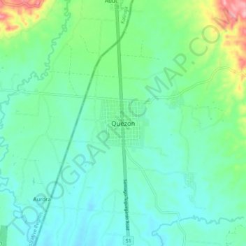
Name: Topografische Karte Quezon, Höhe, Relief.
Ort: Quezon, Isabela, Cagayan Valley, 3324, Philippines (17.27194 121.56539 17.35194 121.64539)
Durchschnittliche Höhe: 113 m
Minimale Höhe: 78 m
Maximale Höhe: 229 m
Andere topografische Karten
Klicken Sie auf eine Karte, um ihre Topografie, ihre Höhe und ihr Relief anzuzeigen.