
Topografische Karte Bolzano - Bozen
Interaktive Karte
Klicken Sie auf die Karte, um die Höhe anzuzeigen.
Über diese Karte
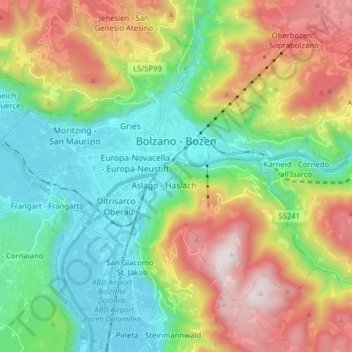
Name: Topografische Karte Bolzano - Bozen, Höhe, Relief.
Durchschnittliche Höhe: 716 m
Minimale Höhe: 221 m
Maximale Höhe: 1.613 m
The area of the city of Bolzano is 52.3 km2 (20 sq. mi.), of which 28 km2 (10 sq. mi.) is used as a settlement area. The city is located in the basin where the Sarntal, Eisacktal, and the Adige Valley with their rivers, Talfer, Eisack, and Adige, meet. In the Middle Ages, the two main Alpine crossings, the Via Claudia Augusta over Reschenpass and the Brenner route over Brenner Pass, met in Bolzano. Thus, the city was very important for the trade. The highest point is 1616 metres (5302') above sea level and the lowest point is 232 metres (761') above sea level. The center is located at an altitude of 262 metres (860') above sea level. The nearest big cities are 58 km (36 miles) (Trento) and 118 km (73 miles) (Innsbruck) away.
Andere topografische Karten
Klicken Sie auf eine Karte, um ihre Topografie, ihre Höhe und ihr Relief anzuzeigen.
Karer See - Lago di Carezza
Italy > Trentino-Alto Adige/Südtirol > South Tyrol > Karersee - Carezza
Karer See - Lago di Carezza, Karersee - Carezza, Welschnofen - Nova Levante, Salten-Schlern - Salto-Sciliar, South Tyrol, Trentino-Alto Adige/Südtirol, 39056, Italy
Durchschnittliche Höhe: 1.606 m
Neustift - Novacella
Italy > Trentino-Alto Adige/Südtirol > South Tyrol
Neustift - Novacella, Vahrn - Varna, Eisacktal - Valle Isarco, South Tyrol, Trentino-Alto Adige/Südtirol, 39040, Italy
Durchschnittliche Höhe: 777 m
Rön
Italy > Trentino-Alto Adige/Südtirol > South Tyrol > Calfosch - Kolfuschg - Colfosco
Rön, Calfosch - Kolfuschg - Colfosco, Corvara in Badia - Corvara, Pustertal - Val Pusteria, South Tyrol, Trentino-Alto Adige/Südtirol, 39033, Italy
Durchschnittliche Höhe: 2.097 m
Sattelnock - Corno del Passo
Italy > Trentino-Alto Adige/Südtirol > South Tyrol > Ahrntal - Valle Aurina
Sattelnock - Corno del Passo, Ahrntal - Valle Aurina, Pustertal - Val Pusteria, South Tyrol, Trentino-Alto Adige/Südtirol, 39030, Italy
Durchschnittliche Höhe: 2.149 m
Al Plan de Mareo - St. Vigil in Enneberg - San Vigilio di Marebbe
Italy > Trentino-Alto Adige/Südtirol > South Tyrol > Marèo - Enneberg - Marebbe
Al Plan de Mareo - St. Vigil in Enneberg - San Vigilio di Marebbe, Marèo - Enneberg - Marebbe, Pustertal - Val Pusteria, South Tyrol, Trentino-Alto Adige/Südtirol, 39030, Italy
Durchschnittliche Höhe: 1.407 m
Million - Col Million
Italy > Trentino-Alto Adige/Südtirol > South Tyrol > Welsberg-Taisten - Monguelfo-Tesido
Million - Col Million, Welsberg-Taisten - Monguelfo-Tesido, Pustertal - Val Pusteria, South Tyrol, Trentino-Alto Adige/Südtirol, Italy
Durchschnittliche Höhe: 2.239 m
Campill - Campiglio
Italy > Trentino-Alto Adige/Südtirol > South Tyrol > St. Lorenzen - San Lorenzo di Sebato
Campill - Campiglio, St. Lorenzen - San Lorenzo di Sebato, Pustertal - Val Pusteria, South Tyrol, Trentino-Alto Adige/Südtirol, 39030, Italy
Durchschnittliche Höhe: 1.926 m
Kurzras - Maso Corto
Italy > Trentino-Alto Adige/Südtirol > South Tyrol > Schnals - Senales
Kurzras - Maso Corto, Schnals - Senales, Vinschgau - Val Venosta, South Tyrol, Trentino-Alto Adige/Südtirol, Italy
Durchschnittliche Höhe: 2.457 m
Tarsch - Tarres
Italy > Trentino-Alto Adige/Südtirol > South Tyrol
Tarsch - Tarres, Latsch - Laces, Vinschgau - Val Venosta, South Tyrol, Trentino-Alto Adige/Südtirol, 39021, Italy
Durchschnittliche Höhe: 978 m
Hafling - Avelengo
Italy > Trentino-Alto Adige/Südtirol > South Tyrol
Hafling - Avelengo, Burggrafenamt - Burgraviato, South Tyrol, Trentino-Alto Adige/Südtirol, 39010, Italy
Durchschnittliche Höhe: 1.228 m
Vintl - Vandoies
Italy > Trentino-Alto Adige/Südtirol > South Tyrol
Vintl - Vandoies, Pustertal - Val Pusteria, South Tyrol, Trentino-Alto Adige/Südtirol, 39030, Italy
Durchschnittliche Höhe: 1.840 m
Etsch - Adige
Italy > Trentino-Alto Adige/Südtirol > South Tyrol > Tarnell - Tarnello > Oberplatz
Etsch - Adige, Oberplatz, Tarnell - Tarnello, Laas - Lasa, Vinschgau - Val Venosta, South Tyrol, Trentino-Alto Adige/Südtirol, 39023, Italy
Durchschnittliche Höhe: 1.075 m
Seis am Schlern - Siusi allo Sciliar
Italy > Trentino-Alto Adige/Südtirol > South Tyrol > Kastelruth - Castelrotto
Seis am Schlern - Siusi allo Sciliar, Kastelruth - Castelrotto, Salten-Schlern - Salto-Sciliar, South Tyrol, Trentino-Alto Adige/Südtirol, Italy
Durchschnittliche Höhe: 1.211 m
Spondinig - Spondigna
Italy > Trentino-Alto Adige/Südtirol > South Tyrol > Schluderns - Sluderno
Spondinig - Spondigna, Schluderns - Sluderno, Vinschgau - Val Venosta, South Tyrol, Trentino-Alto Adige/Südtirol, 39026, Italy
Durchschnittliche Höhe: 1.083 m
Tirol - Tirolo
Italy > Trentino-Alto Adige/Südtirol > South Tyrol
Tirol - Tirolo, Burggrafenamt - Burgraviato, South Tyrol, Trentino-Alto Adige/Südtirol, 39019, Italy
Durchschnittliche Höhe: 1.098 m
Aldein - Aldino
Italy > Trentino-Alto Adige/Südtirol > South Tyrol
Aldein - Aldino, Überetsch-Unterland - Oltradige-Bassa Atesina, South Tyrol, Trentino-Alto Adige/Südtirol, Italy
Durchschnittliche Höhe: 995 m
Lüsen - Luson
Italy > Trentino-Alto Adige/Südtirol > South Tyrol
Lüsen - Luson, Eisacktal - Valle Isarco, South Tyrol, Trentino-Alto Adige/Südtirol, Italy
Durchschnittliche Höhe: 1.646 m
Steinhaus - Cadipietra
Italy > Trentino-Alto Adige/Südtirol > South Tyrol > Ahrntal - Valle Aurina
Steinhaus - Cadipietra, Ahrntal - Valle Aurina, Pustertal - Val Pusteria, South Tyrol, Trentino-Alto Adige/Südtirol, Italy
Durchschnittliche Höhe: 1.491 m
Prags - Braies
Italy > Trentino-Alto Adige/Südtirol > South Tyrol
Prags - Braies, Pustertal - Val Pusteria, South Tyrol, Trentino-Alto Adige/Südtirol, Italy
Durchschnittliche Höhe: 1.878 m
Olang - Valdaora
Italy > Trentino-Alto Adige/Südtirol > South Tyrol
Olang - Valdaora, Pustertal - Val Pusteria, South Tyrol, Trentino-Alto Adige/Südtirol, Italy
Durchschnittliche Höhe: 1.585 m
Passo dello Stelvio
Italy > Trentino-Alto Adige/Südtirol > South Tyrol > Stilfs - Stelvio
Passo dello Stelvio, Stilfs - Stelvio, Vinschgau - Val Venosta, South Tyrol, Trentino-Alto Adige/Südtirol, 39029, Italy
Durchschnittliche Höhe: 2.724 m
Lajen - Laion
Italy > Trentino-Alto Adige/Südtirol > South Tyrol
Lajen - Laion, Eisacktal - Valle Isarco, South Tyrol, Trentino-Alto Adige/Südtirol, 39040, Italy
Durchschnittliche Höhe: 1.065 m
Nals - Nalles
Italy > Trentino-Alto Adige/Südtirol > South Tyrol
Nals - Nalles, Burggrafenamt - Burgraviato, South Tyrol, Trentino-Alto Adige/Südtirol, Italy
Durchschnittliche Höhe: 580 m
St. Peter - San Pietro
Italy > Trentino-Alto Adige/Südtirol > South Tyrol > Lajen - Laion
St. Peter - San Pietro, Lajen - Laion, Eisacktal - Valle Isarco, South Tyrol, Trentino-Alto Adige/Südtirol, Italy
Durchschnittliche Höhe: 1.314 m
Villnößtal - Val di Funes
Italy > Trentino-Alto Adige/Südtirol > South Tyrol
Villnößtal - Val di Funes, Villnöß - Funes, Eisacktal - Valle Isarco, South Tyrol, Trentino-Alto Adige/Südtirol, 39043, Italy
Durchschnittliche Höhe: 1.590 m
Jü de Börz - Würzjoch - Passo delle Erbe
Italy > Trentino-Alto Adige/Südtirol > South Tyrol > San Martin de Tor - San Martino in Badia - St. Martin in Thurn
Jü de Börz - Würzjoch - Passo delle Erbe, San Martin de Tor - San Martino in Badia - St. Martin in Thurn, Pustertal - Val Pusteria, South Tyrol, Trentino-Alto Adige/Südtirol, 39030, Italy
Durchschnittliche Höhe: 1.934 m
Geiselsberg - Sorafurcia
Italy > Trentino-Alto Adige/Südtirol > South Tyrol > Olang - Valdaora
Geiselsberg - Sorafurcia, Olang - Valdaora, Pustertal - Val Pusteria, South Tyrol, Trentino-Alto Adige/Südtirol, Italy
Durchschnittliche Höhe: 1.488 m
St. Peter - San Pietro
Italy > Trentino-Alto Adige/Südtirol > South Tyrol > Bolzano - Bozen
St. Peter - San Pietro, Centro-Piani-Rencio - Zentrum-Bozner Boden-Rentsch, Bolzano - Bozen, South Tyrol, Trentino-Alto Adige/Südtirol, 39190, Italy
Durchschnittliche Höhe: 522 m
Antholzer See - Lago di Anterselva
Italy > Trentino-Alto Adige/Südtirol > South Tyrol > Rasen-Antholz - Rasun-Anterselva
Antholzer See - Lago di Anterselva, Rasen-Antholz - Rasun-Anterselva, Pustertal - Val Pusteria, South Tyrol, Trentino-Alto Adige/Südtirol, Italy
Durchschnittliche Höhe: 1.890 m
Reischach - Riscone
Italy > Trentino-Alto Adige/Südtirol > South Tyrol > Bruneck - Brunico
Reischach - Riscone, Bruneck - Brunico, Pustertal - Val Pusteria, South Tyrol, Trentino-Alto Adige/Südtirol, 39031, Italy
Durchschnittliche Höhe: 1.022 m
Mellaun - Meluno
Italy > Trentino-Alto Adige/Südtirol > South Tyrol > Brixen - Bressanone
Mellaun - Meluno, Brixen - Bressanone, Eisacktal - Valle Isarco, South Tyrol, Trentino-Alto Adige/Südtirol, 39042, Italy
Durchschnittliche Höhe: 974 m
Marèo - Enneberg - Marebbe
Italy > Trentino-Alto Adige/Südtirol > South Tyrol
Marèo - Enneberg - Marebbe, Pustertal - Val Pusteria, South Tyrol, Trentino-Alto Adige/Südtirol, 39030, Italy
Durchschnittliche Höhe: 1.878 m
St. Zyprian - San Cipriano
Italy > Trentino-Alto Adige/Südtirol > South Tyrol
St. Zyprian - San Cipriano, Tiers - Tires, Salten-Schlern - Salto-Sciliar, South Tyrol, Trentino-Alto Adige/Südtirol, 39056, Italy
Durchschnittliche Höhe: 1.454 m
Burjé
Italy > Trentino-Alto Adige/Südtirol > South Tyrol > Corvara in Badia - Corvara
Burjé, Corvara in Badia - Corvara, Pustertal - Val Pusteria, South Tyrol, Trentino-Alto Adige/Südtirol, 39033, Italy
Durchschnittliche Höhe: 1.833 m
Oberglaning - Cologna di Sopra
Italy > Trentino-Alto Adige/Südtirol > South Tyrol > Jenesien - San Genesio Atesino
Oberglaning - Cologna di Sopra, Jenesien - San Genesio Atesino, Salten-Schlern - Salto-Sciliar, South Tyrol, Trentino-Alto Adige/Südtirol, 39050, Italy
Durchschnittliche Höhe: 844 m
Weissenbach - Rio Bianco
Italy > Trentino-Alto Adige/Südtirol > South Tyrol > Sarntal - Sarentino
Weissenbach - Rio Bianco, Sarntal - Sarentino, Salten-Schlern - Salto-Sciliar, South Tyrol, Trentino-Alto Adige/Südtirol, Italy
Durchschnittliche Höhe: 1.716 m
Sulden - Solda
Italy > Trentino-Alto Adige/Südtirol > South Tyrol > Stilfs - Stelvio
Sulden - Solda, Stilfs - Stelvio, Vinschgau - Val Venosta, South Tyrol, Trentino-Alto Adige/Südtirol, 39029, Italy
Durchschnittliche Höhe: 2.232 m
Bundschen - Ponticino
Italy > Trentino-Alto Adige/Südtirol > South Tyrol > Sarntal - Sarentino
Bundschen - Ponticino, Sarntal - Sarentino, Salten-Schlern - Salto-Sciliar, South Tyrol, Trentino-Alto Adige/Südtirol, 39059, Italy
Durchschnittliche Höhe: 1.215 m
Kaltern an der Weinstraße - Caldaro sulla Strada del Vino
Italy > Trentino-Alto Adige/Südtirol > South Tyrol
Kaltern an der Weinstraße - Caldaro sulla Strada del Vino, Überetsch-Unterland - Oltradige-Bassa Atesina, South Tyrol, Trentino-Alto Adige/Südtirol, 39052, Italy
Durchschnittliche Höhe: 798 m
Brixen - Bressanone
Italy > Trentino-Alto Adige/Südtirol > South Tyrol
Brixen - Bressanone, Eisacktal - Valle Isarco, South Tyrol, Trentino-Alto Adige/Südtirol, 39042, Italy
Durchschnittliche Höhe: 1.307 m
Pragser Wildsee - Lago di Braies
Italy > Trentino-Alto Adige/Südtirol > South Tyrol > Prags - Braies
Pragser Wildsee - Lago di Braies, Prags - Braies, Pustertal - Val Pusteria, South Tyrol, Trentino-Alto Adige/Südtirol, Italy
Durchschnittliche Höhe: 1.744 m
Kronplatz - Plan de Corones
Italy > Trentino-Alto Adige/Südtirol > South Tyrol > Bruneck - Brunico
Kronplatz - Plan de Corones, Bruneck - Brunico, Pustertal - Val Pusteria, South Tyrol, Trentino-Alto Adige/Südtirol, Italy
Durchschnittliche Höhe: 1.953 m
Heiss
Italy > Trentino-Alto Adige/Südtirol > South Tyrol > Sarntal - Sarentino > Weissenbach - Rio Bianco
Heiss, Weissenbach - Rio Bianco, Sarntal - Sarentino, Salten-Schlern - Salto-Sciliar, South Tyrol, Trentino-Alto Adige/Südtirol, Italy
Durchschnittliche Höhe: 1.686 m
Runcadic - Runggaditsch - Roncadizza
Italy > Trentino-Alto Adige/Südtirol > South Tyrol > Kastelruth - Castelrotto
Runcadic - Runggaditsch - Roncadizza, Kastelruth - Castelrotto, Salten-Schlern - Salto-Sciliar, South Tyrol, Trentino-Alto Adige/Südtirol, 39046, Italy
Durchschnittliche Höhe: 1.520 m
Ras
Italy > Trentino-Alto Adige/Südtirol > South Tyrol > Marèo - Enneberg - Marebbe > Al Plan de Mareo - St. Vigil in Enneberg - San Vigilio di Marebbe
Ras, Al Plan de Mareo - St. Vigil in Enneberg - San Vigilio di Marebbe, Marèo - Enneberg - Marebbe, Pustertal - Val Pusteria, South Tyrol, Trentino-Alto Adige/Südtirol, 39030, Italy
Durchschnittliche Höhe: 1.397 m
Uttenheim - Villa Ottone
Italy > Trentino-Alto Adige/Südtirol > South Tyrol
Uttenheim - Villa Ottone, Gais, Pustertal - Val Pusteria, South Tyrol, Trentino-Alto Adige/Südtirol, Italy
Durchschnittliche Höhe: 1.260 m
Nauders - San Benedetto
Italy > Trentino-Alto Adige/Südtirol > South Tyrol
Nauders - San Benedetto, Rodeneck - Rodengo, Eisacktal - Valle Isarco, South Tyrol, Trentino-Alto Adige/Südtirol, 39037, Italy
Durchschnittliche Höhe: 996 m
Partschins - Parcines
Italy > Trentino-Alto Adige/Südtirol > South Tyrol
Partschins - Parcines, Burggrafenamt - Burgraviato, South Tyrol, Trentino-Alto Adige/Südtirol, Italy
Durchschnittliche Höhe: 1.522 m
Kiens - Chienes
Italy > Trentino-Alto Adige/Südtirol > South Tyrol
Kiens - Chienes, Pustertal - Val Pusteria, South Tyrol, Trentino-Alto Adige/Südtirol, 39030, Italy
Durchschnittliche Höhe: 1.452 m
Völs am Schlern - Fiè allo Sciliar
Italy > Trentino-Alto Adige/Südtirol > South Tyrol
Völs am Schlern - Fiè allo Sciliar, Salten-Schlern - Salto-Sciliar, South Tyrol, Trentino-Alto Adige/Südtirol, Italy
Durchschnittliche Höhe: 1.132 m