
Topografische Karte Passo dello Stelvio
Interaktive Karte
Klicken Sie auf die Karte, um die Höhe anzuzeigen.
Über diese Karte
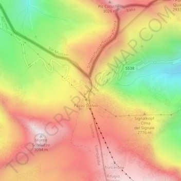
Name: Topografische Karte Passo dello Stelvio, Höhe, Relief.
Durchschnittliche Höhe: 2.724 m
Minimale Höhe: 2.261 m
Maximale Höhe: 3.075 m
The Stelvio Pass (Italian: Passo dello Stelvio [passo ˈdello ˈstɛlvjo], Giogo dello Stelvio [dʒɔgo ˈdello ˈstɛlvjo]; German: Stilfser Joch; [ˈʃtɪlfsɐ jɔx]) is a mountain pass in northern Italy bordering Switzerland at an elevation of 2,757 m (9,045 ft) above sea level. It is the highest paved mountain pass in the Eastern Alps, and the second highest in the Alps, 7 m (23 ft) below France's Col de l'Iseran (2,764 m (9,068 ft)).
Andere topografische Karten
Klicken Sie auf eine Karte, um ihre Topografie, ihre Höhe und ihr Relief anzuzeigen.
Sulden - Solda
Italy > Trentino-Alto Adige/Südtirol > South Tyrol > Stilfs - Stelvio
Sulden - Solda, Stilfs - Stelvio, Vinschgau - Val Venosta, South Tyrol, Trentino-Alto Adige/Südtirol, 39029, Italy
Durchschnittliche Höhe: 2.232 m
Neuwies - Pratonuovo
Italy > Trentino-Alto Adige/Südtirol > South Tyrol > Stilfs - Stelvio > Trafoi
Neuwies - Pratonuovo, Trafoi, Stilfs - Stelvio, Vinschgau - Val Venosta, South Tyrol, Trentino-Alto Adige/Südtirol, 39029, Italy
Durchschnittliche Höhe: 2.088 m