
Topografische Karte Grand Teton National Park
Interaktive Karte
Klicken Sie auf die Karte, um die Höhe anzuzeigen.
Über diese Karte
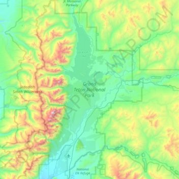
Name: Topografische Karte Grand Teton National Park, Höhe, Relief.
Durchschnittliche Höhe: 2.409 m
Minimale Höhe: 1.893 m
Maximale Höhe: 4.117 m
Grand Teton National Park is named for Grand Teton, the tallest mountain in the Teton Range. The naming of the mountains is attributed to early 19th-century French-speaking trappers—les trois tétons (the three teats) was later anglicized and shortened to Tetons. At 13,775 feet (4,199 m), Grand Teton abruptly rises more than 7,000 feet (2,100 m) above Jackson Hole, almost 850 feet (260 m) higher than Mount Owen, the second-highest summit in the range. The park has numerous lakes, including 15-mile-long (24 km) Jackson Lake as well as streams of varying length and the upper main stem of the Snake River. Though in a state of recession, a dozen small glaciers persist at the higher elevations near the highest peaks in the range. Some of the rocks in the park are the oldest found in any American national park and have been dated at nearly 2.7 billion years.
Andere topografische Karten
Klicken Sie auf eine Karte, um ihre Topografie, ihre Höhe und ihr Relief anzuzeigen.
Teton Village
United States > Wyoming > Teton County
Teton Village, Teton County, Wyoming, 83025, United States
Durchschnittliche Höhe: 2.144 m
Pacific Creek
United States > Wyoming > Teton County
Pacific Creek, Teton County, Wyoming, United States
Durchschnittliche Höhe: 2.434 m
Isa Lake
United States > Wyoming > Teton County
Isa Lake, Teton County, Wyoming, United States
Durchschnittliche Höhe: 2.503 m
Rocky Mountains
United States > Wyoming > Teton County
Rocky Mountains, Teton County, Wyoming, United States
Durchschnittliche Höhe: 2.292 m
Jackson
United States > Wyoming > Teton County
Jackson, Teton County, Wyoming, 83002, United States
Durchschnittliche Höhe: 2.043 m
Disappointment Peak
United States > Wyoming > Teton County
Disappointment Peak, Teton County, Wyoming, United States
Durchschnittliche Höhe: 3.255 m
Moran
United States > Wyoming > Teton County > Moran
Moran, Teton County, Wyoming, United States
Durchschnittliche Höhe: 2.088 m
Upper Geyser Basin
United States > Wyoming > Teton County > Upper Geyser Basin
Upper Geyser Basin, Teton County, Wyoming, United States
Durchschnittliche Höhe: 2.295 m
Buck Mountain
United States > Wyoming > Teton County
Buck Mountain, Teton County, Wyoming, United States
Durchschnittliche Höhe: 3.128 m
Grand Teton
United States > Wyoming > Teton County
Grand Teton, Teton County, Wyoming, United States
Durchschnittliche Höhe: 3.330 m
Yellowstone Lake
United States > Wyoming > Teton County
Yellowstone Lake, Teton County, Wyoming, United States
Durchschnittliche Höhe: 2.453 m