
Topografische Karte Teton Village
Klicken Sie auf die Karte, um die Höhe anzuzeigen.
Über diese Karte
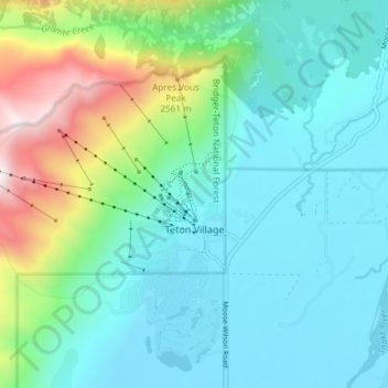
Name: Topografische Karte Teton Village, Höhe, Relief.
Ort: Teton Village, Teton County, Wyoming, United States (43.57385 -110.87976 43.61177 -110.80548)
Durchschnittliche Höhe: 2.144 m
Minimale Höhe: 1.906 m
Maximale Höhe: 2.990 m
Andere topografische Karten
Klicken Sie auf eine Karte, um ihre Topografie, ihre Höhe und ihr Relief anzuzeigen.
Buck Mountain
United States > Wyoming > Teton County
Buck Mountain (elevation: 11,943 feet (3,640 m)) is a mountain located in the Teton Range, Grand Teton National Park, Wyoming, immediately southeast of Grand Teton.
Durchschnittliche Höhe: 3.128 m
Rocky Mountains
United States > Wyoming > Teton County
Agriculture and forestry are major industries. Agriculture includes dryland and irrigated farming and livestock grazing. Livestock are frequently moved between high-elevation summer pastures and low-elevation winter pastures, a practice known as transhumance.
Durchschnittliche Höhe: 2.292 m
Jenny Lake
United States > Wyoming > Teton County
Jenny Lake is a starting point for many day and overnight hiking trips. The 7.1-mile (11.4 km) Jenny Lake Trail loops around the lake and is considered to be relatively easy due to the small altitude gain of 700 feet (210 m). However, the altitude increases rapidly once Cascade Canyon is entered.
Durchschnittliche Höhe: 2.109 m
Rocky Mountains
United States > Wyoming > Teton County
Agriculture and forestry are major industries. Agriculture includes dryland and irrigated farming and livestock grazing. Livestock are frequently moved between high-elevation summer pastures and low-elevation winter pastures, a practice known as transhumance.
Durchschnittliche Höhe: 2.292 m
Old Faithful
United States > Wyoming > Teton County > Upper Geyser Basin
Durchschnittliche Höhe: 2.284 m
Teton Range
United States > Wyoming > Teton County
One reason the Teton Range is famous is because of the dramatic elevation profile visible from the eastern side, which rises sharply from 4,000 to 7,000 feet (1,200–2,100 m) above the valley floor. Unlike most mountain ranges, the east side of the Teton Range lacks significant foothills or lower peaks which…
Durchschnittliche Höhe: 2.985 m
Rendezvous Mountain
United States > Wyoming > Teton County > Teton Village
Durchschnittliche Höhe: 2.829 m
Togwotee Pass
United States > Wyoming > Teton County
Togwotee Pass (pronounced TOH-guh-tee) is a high mountain pass in the western United States, at an elevation of 9,655 feet (2,943 m) above sea level. On the Continental Divide in the Absaroka Range of northwestern Wyoming in Teton County, it is between Dubois and Moran Junction in the Jackson Hole valley.
Durchschnittliche Höhe: 2.965 m
Rocky Mountains
United States > Wyoming > Teton County
Agriculture and forestry are major industries. Agriculture includes dryland and irrigated farming and livestock grazing. Livestock are frequently moved between high-elevation summer pastures and low-elevation winter pastures, a practice known as transhumance.
Durchschnittliche Höhe: 2.292 m
Buck Mountain
United States > Wyoming > Teton County
Buck Mountain (elevation: 11,943 feet (3,640 m)) is a mountain located in the Teton Range, Grand Teton National Park, Wyoming, immediately southeast of Grand Teton.
Durchschnittliche Höhe: 3.128 m
Old Faithful
United States > Wyoming > Teton County > Upper Geyser Basin
Durchschnittliche Höhe: 2.284 m
Yellowstone Caldera Supervolcano
United States > Wyoming > Teton County
Durchschnittliche Höhe: 2.530 m
Yellowstone Caldera Supervolcano
United States > Wyoming > Teton County
Durchschnittliche Höhe: 2.530 m
Buck Mountain
United States > Wyoming > Teton County
Buck Mountain (elevation: 11,943 feet (3,640 m)) is a mountain located in the Teton Range, Grand Teton National Park, Wyoming, immediately southeast of Grand Teton.
Durchschnittliche Höhe: 3.128 m
Upper Geyser Basin
United States > Wyoming > Teton County > Upper Geyser Basin
Durchschnittliche Höhe: 2.295 m