
Topografische Karte Paluan
Klicken Sie auf die Karte, um die Höhe anzuzeigen.
Paluan
The town is located at the north-western tip of Mindoro Island. It lies along the north-east shore of Paluan Bay, approximately 7 miles southeast of Cape Calavite, a major sea-lane for inter-island and ocean-going vessels. The town is surrounded by rolling and steep mountain ranges, of which Mount Calavite with an altitude of 1,491 metres (4,892 ft) is the highest peak. At Mount Calavite point, the best panoramic view of Occidental Mindoro and nearby islands could be seen.
Über diese Karte
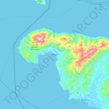
Name: Topografische Karte Paluan, Höhe, Relief.
Ort: Paluan, Occidental Mindoro, Mimaropa, Philippines (13.18897 120.16005 13.64328 120.61245)
Durchschnittliche Höhe: 113 m
Minimale Höhe: 0 m
Maximale Höhe: 1.490 m
Andere topografische Karten
Klicken Sie auf eine Karte, um ihre Topografie, ihre Höhe und ihr Relief anzuzeigen.
Cabra Island
Philippines > Occidental Mindoro > Lubang
With a length of about 4.5 km (2.8 miles) and about 2.9 km (1.8 miles) at its widest, the island has a flat terrain with the highest elevation at 60.96 metres (around 200 feet). A particular rock islet near one beach is considered by locals as a symbol of the island given its shape as a cabra (Spanish for…
Durchschnittliche Höhe: 17 m
Wawa Lighthouse
Philippines > Occidental Mindoro > Abra de Ilog > Lumang Bayan
Durchschnittliche Höhe: 26 m
Sablayan Town Plaza
Philippines > Occidental Mindoro > Sablayan > Buenavista
Durchschnittliche Höhe: 9 m