
Vielen Dank für die Unterstützung dieser Website ❤️
Spenden
Spenden
Topografische Karte Cabra Island
Klicken Sie auf die Karte, um die Höhe anzuzeigen.
Vielen Dank für die Unterstützung dieser Website ❤️
Spenden
Spenden
Cabra Island
With a length of about 4.5 km (2.8 miles) and about 2.9 km (1.8 miles) at its widest, the island has a flat terrain with the highest elevation at 60.96 metres (around 200 feet). A particular rock islet near one beach is considered by locals as a symbol of the island given its shape as a cabra (Spanish for “goat”). The Cabra Island Lighthouse complex is located on Cabra Island.
Vielen Dank für die Unterstützung dieser Website ❤️
Spenden
Spenden
Über diese Karte
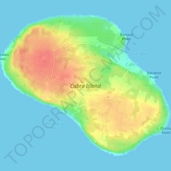
Name: Topografische Karte Cabra Island, Höhe, Relief.
Durchschnittliche Höhe: 17 m
Minimale Höhe: -1 m
Maximale Höhe: 56 m
Vielen Dank für die Unterstützung dieser Website ❤️
Spenden
Spenden
Andere topografische Karten
Klicken Sie auf eine Karte, um ihre Topografie, ihre Höhe und ihr Relief anzuzeigen.