
Spenden
Topografische Karte Mount Blackwood
Klicken Sie auf die Karte, um die Höhe anzuzeigen.
Spenden
Über diese Karte
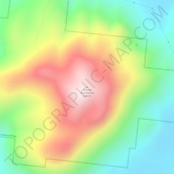
Name: Topografische Karte Mount Blackwood, Höhe, Relief.
Ort: Mount Blackwood, Mackay Regional, Queensland, Australia (-21.03176 148.94369 -21.03166 148.94379)
Durchschnittliche Höhe: 285 m
Minimale Höhe: 32 m
Maximale Höhe: 577 m
Spenden
Andere topografische Karten
Klicken Sie auf eine Karte, um ihre Topografie, ihre Höhe und ihr Relief anzuzeigen.
Mount Coot-tha
Australia > Queensland > City of Brisbane
It is often claimed that Mount Coot-tha is the "highest point in Brisbane", but, as the elevations above show, the peak known as Mount Coot-tha is not even the highest peak of the mountain as a whole with both Constitution Hill and The Summit being higher. However, Mount Coot-tha has a lookout with unobscured…
Durchschnittliche Höhe: 88 m
City of Brisbane
Brisbane's topography is characterized by a series of hills and ranges that define its landscape. The city is situated on a low-lying floodplain, with the Brisbane River meandering through its heart, creating a winding course with many steep curves from the southwest to its mouth at Moreton Bay in the east.…
Durchschnittliche Höhe: 71 m
Spenden
Brisbane River
The RAAF also perform a practice session in the days preceding the event, serving as an opportunity to both practice beforehand and also promote Riverfire. One of the most popular RAAF aircraft to perform at Riverfire was the F-111 which was known for performing a 'dump-and-burn' above the city. The final…
Durchschnittliche Höhe: 235 m
Spenden
Spenden
Spenden
Spenden
Spenden
Spenden
Spenden
Spenden
Alexandra Hills
Scribbly Gums Conservation Area is located on the eastern edge of Alexandra Hills, bordered by Redland Hospital to the east, and Flinders St and Winchester Rd to the north. The conservation area occupies approximately 152 hectares and contains the Redlands Track Park - a collection of 30+ mountain bike trails…
Durchschnittliche Höhe: 34 m
Spenden
Spenden
Spenden
Spenden
Sunshine Coast Regional
The Sunshine Coast Regional area in Queensland, Australia, features a diverse topography that ranges from coastal plains to rugged hinterlands. Along the coastline, the terrain is predominantly flat, with average elevations around 20 meters (66 feet) above sea level. Inland, the landscape transitions to…
Durchschnittliche Höhe: 56 m
Spenden
Spenden
Spenden
Spenden
Spenden
Minyama
Australia > Queensland > Sunshine Coast Regional
Minyama is located within the Kawana Waters urban centre. Situated on the Mooloolah River, the suburb is almost entirely surrounded by water, and artificially constructed harbours and waterways dominate the topography. The suburb's main thoroughfare, Nicklin Way, is the location of several large retail…
Durchschnittliche Höhe: 3 m
Spenden
Stanthorpe
Owing to its elevation, Stanthorpe features a subtropical highland climate (Cfb). At an altitude of 811 metres (2,661 ft), Stanthorpe holds the record for the lowest temperature recorded in Queensland at −10.6 °C (12.9 °F) on 23 June 1961.
Durchschnittliche Höhe: 831 m
Spenden
Spenden
Lama Lama National Park (Cape York Peninsula Aboriginal Land)
Durchschnittliche Höhe: 86 m
Spenden
Spenden
Spenden
Spenden