Geolokalisieren

Topografische Karte Buckinghamshire

Interaktive Karte

Klicken Sie auf die Karte, um die Höhe anzuzeigen.

Über diese Karte

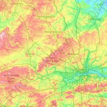
Name: Topografische Karte Buckinghamshire, Höhe, Relief.

Ort: Buckinghamshire, South East England, England, HP22 6EQ, United Kingdom (51.05000 -1.45000 52.45000 -0.05000)

Durchschnittliche Höhe: 92 m

Minimale Höhe: -3 m

Maximale Höhe: 318 m

Andere topografische Karten

Klicken Sie auf eine Karte, um ihre Topografie, ihre Höhe und ihr Relief anzuzeigen.

London

United Kingdom > England > London

Durchschnittliche Höhe: 77 m

Stonehenge

United Kingdom > England > Larkhill

Durchschnittliche Höhe: 99 m

Sunderland

United Kingdom > England

Durchschnittliche Höhe: 46 m

Stevenage

United Kingdom > England > Hertfordshire

Durchschnittliche Höhe: 108 m

Jurassic Coast

United Kingdom > England > Dorset > Bridport

Durchschnittliche Höhe: 49 m

Brighton and Hove

United Kingdom > England

Durchschnittliche Höhe: 63 m

Brinklow CP

United Kingdom > England > Warwickshire > Rugby

Durchschnittliche Höhe: 90 m

Dunchurch

United Kingdom > England > Warwickshire > Rugby

Durchschnittliche Höhe: 102 m

West Midlands

United Kingdom > England > Warwickshire

Durchschnittliche Höhe: 113 m

Coniston

United Kingdom > England > Westmorland and Furness

Durchschnittliche Höhe: 283 m

Mote Park

United Kingdom > England > Kent > Maidstone > Otham

Durchschnittliche Höhe: 52 m

Rushmere St Andrew

United Kingdom > England > Suffolk > East Suffolk

Durchschnittliche Höhe: 37 m

Hampshire

United Kingdom > England

Durchschnittliche Höhe: 73 m

Barming

United Kingdom > England > Kent > Maidstone > East Farleigh

Durchschnittliche Höhe: 57 m

River Severn

United Kingdom > England

The River Severn (Welsh: Afon Hafren, pronounced [ˈavɔn ˈhavrɛn]), at 220 miles (354 km) long, is the longest river in Great Britain. It is also the river with the most voluminous flow of water by far in all of England and Wales, with an average flow rate of 107 m3/s (3,800 cu ft/s) at Apperley,…

Durchschnittliche Höhe: 168 m

Wickersley

United Kingdom > England > Rotherham

Durchschnittliche Höhe: 116 m

Louth

United Kingdom > England > Lincolnshire > East Lindsey

Durchschnittliche Höhe: 43 m

Dorchester

United Kingdom > England > Dorset

Durchschnittliche Höhe: 72 m

Melksham

United Kingdom > England > Wiltshire > Melksham

Durchschnittliche Höhe: 41 m

Dunkeswell

United Kingdom > England > Devon > East Devon

Durchschnittliche Höhe: 218 m

Audlem

United Kingdom > England > Cheshire East

Durchschnittliche Höhe: 72 m

Beaconsfield

United Kingdom > England > Buckinghamshire

Durchschnittliche Höhe: 103 m

Nether Compton

United Kingdom > England > Dorset

Durchschnittliche Höhe: 85 m

Shap

United Kingdom > England > Westmorland and Furness

Durchschnittliche Höhe: 301 m

Eye

United Kingdom > England > Suffolk

Durchschnittliche Höhe: 44 m

North Gosforth

United Kingdom > England > Newcastle upon Tyne

Durchschnittliche Höhe: 58 m

Gislingham

United Kingdom > England > Suffolk

Durchschnittliche Höhe: 56 m

Hawkshead

United Kingdom > England > Westmorland and Furness

Durchschnittliche Höhe: 148 m

Wilsden

United Kingdom > England > Bradford

Durchschnittliche Höhe: 207 m

Thorpe Market

United Kingdom > England > Norfolk > North Norfolk

Durchschnittliche Höhe: 42 m

Weybridge

United Kingdom > England > Surrey > Elmbridge

Durchschnittliche Höhe: 24 m

Oxenhope

United Kingdom > England > Bradford

Durchschnittliche Höhe: 332 m

Woodeaton

United Kingdom > England > Oxfordshire > South Oxfordshire

Durchschnittliche Höhe: 72 m

Derby

United Kingdom > England

Durchschnittliche Höhe: 70 m

Hemyock

United Kingdom > England > Devon > Mid Devon

Durchschnittliche Höhe: 192 m

Watford

United Kingdom > England > Hertfordshire

Durchschnittliche Höhe: 77 m

Shortstown

United Kingdom > England > Bedford

Durchschnittliche Höhe: 30 m

The Weald

United Kingdom > England

Neither the thin infertile sands of the High Weald or the wet sticky clays of the Low Weald are suited to intensive arable farming and the topography of the area often increases the difficulties. There are limited areas of fertile greensand which can be used for intensive vegetable growing, as in the valley of…

Durchschnittliche Höhe: 41 m

Holbeach CP

United Kingdom > England > Lincolnshire > South Holland

Durchschnittliche Höhe: 3 m

Bordon

United Kingdom > England > Hampshire > East Hampshire > Hollywater

Durchschnittliche Höhe: 82 m

Isle of Wight

United Kingdom > England

Durchschnittliche Höhe: 17 m

Mayfield Park

United Kingdom > England > Manchester

Durchschnittliche Höhe: 47 m

Swynnerton

United Kingdom > England > Staffordshire > Stafford

Durchschnittliche Höhe: 133 m

Wolston CP

United Kingdom > England > Warwickshire > Rugby

Durchschnittliche Höhe: 89 m

Ashley Green

United Kingdom > England > Buckinghamshire

Durchschnittliche Höhe: 156 m

High Wycombe

United Kingdom > England > Buckinghamshire

Durchschnittliche Höhe: 125 m

Taylor's Island

United Kingdom > England > Hugh Town > Porthloo

Durchschnittliche Höhe: 11 m

Burnley

United Kingdom > England > Lancashire

The town lies in a natural three-forked valley at the confluence of the River Brun and the River Calder, surrounded by open fields, with wild moorland at higher altitudes. To the west of Burnley lie the towns of Padiham, Accrington and Blackburn, with Nelson and Colne to the north. The centre of the town…

Durchschnittliche Höhe: 247 m

Hertfordshire

United Kingdom > England

Elevations are higher in the north and west, reaching more than 800 feet (240 m) in the Chilterns near Tring. The county centres on the headwaters and upper valleys of the rivers Lea and the Colne; both flow south and each is accompanied by a canal. Hertfordshire's undeveloped land is mainly agricultural and…

Durchschnittliche Höhe: 82 m

Telford and Wrekin

United Kingdom > England

Durchschnittliche Höhe: 90 m

Wells

United Kingdom > England > Somerset

Durchschnittliche Höhe: 69 m

Whiteley

United Kingdom > England > Hampshire > Winchester

Durchschnittliche Höhe: 27 m

Kettering

United Kingdom > England > Kettering

Durchschnittliche Höhe: 100 m

Pavenham

United Kingdom > England > Bedford

Durchschnittliche Höhe: 57 m

Hascombe

United Kingdom > England > Surrey > Waverley

Durchschnittliche Höhe: 122 m

Sandbach

United Kingdom > England > Cheshire East

Durchschnittliche Höhe: 64 m

River Frome

United Kingdom > England > Somerset > Hinton Charterhouse

Durchschnittliche Höhe: 108 m

Shirebrook

United Kingdom > England > Derbyshire

Durchschnittliche Höhe: 114 m

River Rea

United Kingdom > England > Worcestershire > Birmingham

Durchschnittliche Höhe: 149 m

Castle Goring

United Kingdom > England > West Sussex > Worthing > Clapham

Durchschnittliche Höhe: 41 m

Matlock Bath CP

United Kingdom > England > Derbyshire > Derbyshire Dales

Durchschnittliche Höhe: 187 m

Cheshire

United Kingdom > England

Durchschnittliche Höhe: 103 m

Wingham

United Kingdom > England > Kent > Dover

Durchschnittliche Höhe: 22 m

Crowland

United Kingdom > England > Lincolnshire > South Holland

Durchschnittliche Höhe: 3 m

Dronfield

United Kingdom > England > Derbyshire > North East Derbyshire

Durchschnittliche Höhe: 167 m

Tintinhull

United Kingdom > England > Somerset

Durchschnittliche Höhe: 27 m

Wicken

United Kingdom > England > Cambridgeshire > East Cambridgeshire

Durchschnittliche Höhe: 3 m

Speen

United Kingdom > England > West Berkshire

Durchschnittliche Höhe: 106 m

Swanland

United Kingdom > England > East Riding of Yorkshire

Durchschnittliche Höhe: 62 m

Fordham

United Kingdom > England > Cambridgeshire > East Cambridgeshire

Durchschnittliche Höhe: 11 m

Great Easton

United Kingdom > England > Uttlesford

Durchschnittliche Höhe: 85 m

Arthuret

United Kingdom > England > Cumberland

Durchschnittliche Höhe: 52 m

Ston Easton

United Kingdom > England > Somerset

Durchschnittliche Höhe: 152 m

Oundle

United Kingdom > England > North Northamptonshire

Durchschnittliche Höhe: 37 m

Grantham

United Kingdom > England > Lincolnshire > South Kesteven

Durchschnittliche Höhe: 85 m

Buckland Dinham

United Kingdom > England > Somerset

Durchschnittliche Höhe: 103 m

Epworth

United Kingdom > England > North Lincolnshire

Durchschnittliche Höhe: 6 m

West Yorkshire

United Kingdom > England

Wakefield's Parish Church was raised to cathedral status in 1888 and after the elevation of Wakefield to diocese, Wakefield Council immediately sought city status and this was granted in July 1888. However the Industrial Revolution, which changed West and South Yorkshire significantly, led to the growth of…

Durchschnittliche Höhe: 172 m

Penrith

United Kingdom > England > Westmorland and Furness

Durchschnittliche Höhe: 164 m

Brockenhurst

United Kingdom > England > Hampshire > New Forest

Durchschnittliche Höhe: 34 m

Warfield

United Kingdom > England > Bracknell Forest > Newell Green

Durchschnittliche Höhe: 64 m

Northamptonshire

United Kingdom > England

Durchschnittliche Höhe: 97 m

White Ladies Aston

United Kingdom > England > Worcestershire > Wychavon

Durchschnittliche Höhe: 43 m

Aston Upthorpe

United Kingdom > England > Oxfordshire > South Oxfordshire

Durchschnittliche Höhe: 87 m

Shippon

United Kingdom > England > Oxfordshire > Vale of White Horse

Durchschnittliche Höhe: 65 m

Cinderford

United Kingdom > England > Gloucestershire > Forest of Dean > Littledean

Durchschnittliche Höhe: 173 m

Aston le Walls

United Kingdom > England > West Northamptonshire

Durchschnittliche Höhe: 140 m

Boston

United Kingdom > England > Lincolnshire

Durchschnittliche Höhe: 3 m

Cadishead Moss

United Kingdom > England > Salford > Irlam

Durchschnittliche Höhe: 21 m

Five Towns Drain

United Kingdom > England > Lincolnshire > Boston > Fosdyke

Durchschnittliche Höhe: 4 m