
Spenden
Topografische Karte Burnley
Klicken Sie auf die Karte, um die Höhe anzuzeigen.
Spenden
Burnley
The town lies in a natural three-forked valley at the confluence of the River Brun and the River Calder, surrounded by open fields, with wild moorland at higher altitudes. To the west of Burnley lie the towns of Padiham, Accrington and Blackburn, with Nelson and Colne to the north. The centre of the town stands at approximately 387 feet (118 m) above sea level and 30 miles (48 km) east of the Irish Sea coast.
Spenden
Über diese Karte
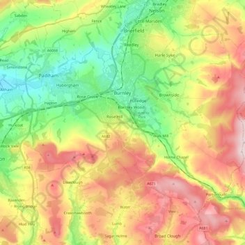
Name: Topografische Karte Burnley, Höhe, Relief.
Ort: Burnley, Lancashire, England, United Kingdom (53.72300 -2.34231 53.82526 -2.11228)
Durchschnittliche Höhe: 247 m
Minimale Höhe: 63 m
Maximale Höhe: 479 m
Spenden
Andere topografische Karten
Klicken Sie auf eine Karte, um ihre Topografie, ihre Höhe und ihr Relief anzuzeigen.
Coppull
United Kingdom > England > Lancashire > Chorley
The settlement has an Anglo Saxon name describing its topography derived from the Old English copp a hill top and hyll a hill. The township was variously recorded as Cophull and Cophulle in 1277, Copphull in 1351, Copthull in 1374 and Coppull from 1444.
Durchschnittliche Höhe: 79 m
Belthorn Reservoir (disused)
United Kingdom > England > Lancashire > Hyndburn > Oswaldtwistle
Durchschnittliche Höhe: 291 m
Spenden
Spenden
Farington Moss
United Kingdom > England > Lancashire > South Ribble > Farington Moss
Durchschnittliche Höhe: 36 m
Spenden