
Topografische Karte County Leitrim
Klicken Sie auf die Karte, um die Höhe anzuzeigen.
Über diese Karte
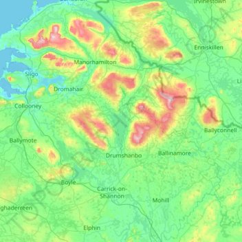
Name: Topografische Karte County Leitrim, Höhe, Relief.
Ort: County Leitrim, Connacht, Ireland (53.80603 -8.42773 54.47435 -7.58417)
Durchschnittliche Höhe: 108 m
Minimale Höhe: -1 m
Maximale Höhe: 652 m
Andere topografische Karten
Klicken Sie auf eine Karte, um ihre Topografie, ihre Höhe und ihr Relief anzuzeigen.
Limerick
Ireland > County Limerick > Limerick
Limerick's climate is classified as temperate oceanic (Köppen Cfb). Met Éireann maintains a climatological weather station at Shannon Airport, 20 kilometres west of the city in County Clare. Shannon Airport records an average of 977 millimetres of precipitation annually, most of which is rain. Limerick has a…
Durchschnittliche Höhe: 10 m