
Topografische Karte Kottayam
Interaktive Karte
Klicken Sie auf die Karte, um die Höhe anzuzeigen.
Über diese Karte
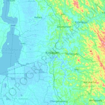
Name: Topografische Karte Kottayam, Höhe, Relief.
Ort: Kottayam, Kottayam District, Kerala, 686001, India (9.43156 76.36216 9.75156 76.68216)
Durchschnittliche Höhe: 19 m
Minimale Höhe: -4 m
Maximale Höhe: 157 m
Kottayam has an average elevation of 3 metres (9.8 ft) above sea level. and is situated in the basin of the Meenachil River and in the basin of the Vembanad backwaters, which are formed from several streams in the Western Ghats in Idukki district. According to the division of places in Kerala based on altitudes, Kottayam is classified as being a midland area. The general soil type is alluvial soil. The vegetation is mainly tropical evergreen and moist deciduous type.
Andere topografische Karten
Klicken Sie auf eine Karte, um ihre Topografie, ihre Höhe und ihr Relief anzuzeigen.
Puthuppally
Puthuppally, Kottayam, Kerala, 686011, India
Durchschnittliche Höhe: 18 m
Thiruvanchoor
India > Kerala > Kottayam > Thiruvanchoor
Thiruvanchoor, Kottayam, Kerala, 686637, India
Durchschnittliche Höhe: 11 m
Karappuzha Temple Kulam
India > Kerala > Kottayam > Kottayam
Karappuzha Temple Kulam, Kottayam, Kerala, India
Durchschnittliche Höhe: 6 m
Paruthumpara
Paruthumpara, Kottayam, Kerala, India
Durchschnittliche Höhe: 19 m
Mattakkara
India > Kerala > Kottayam > Mattakkara
Mattakkara, Kottayam, Kerala, 686564, India
Durchschnittliche Höhe: 41 m