
Vielen Dank für die Unterstützung dieser Website ❤️
Spenden
Spenden
Topografische Karte Pampady
Klicken Sie auf die Karte, um die Höhe anzuzeigen.
Vielen Dank für die Unterstützung dieser Website ❤️
Spenden
Spenden
Über diese Karte
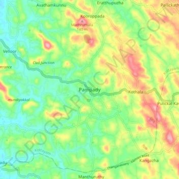
Name: Topografische Karte Pampady, Höhe, Relief.
Ort: Pampady, Kottayam, Kerala, 686502, India (9.52563 76.60436 9.60563 76.68436)
Durchschnittliche Höhe: 55 m
Minimale Höhe: 4 m
Maximale Höhe: 135 m
Vielen Dank für die Unterstützung dieser Website ❤️
Spenden
Spenden
Andere topografische Karten
Klicken Sie auf eine Karte, um ihre Topografie, ihre Höhe und ihr Relief anzuzeigen.