
Topografische Karte Uva Province
Interaktive Karte
Klicken Sie auf die Karte, um die Höhe anzuzeigen.
Über diese Karte
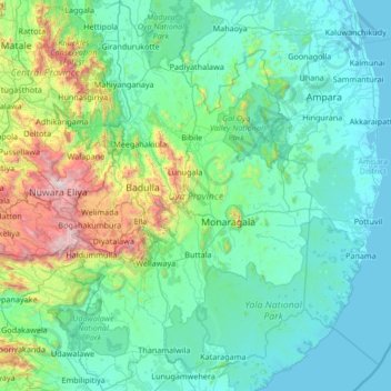
Name: Topografische Karte Uva Province, Höhe, Relief.
Ort: Uva Province, Sri Lanka (6.29647 80.77594 7.62496 81.63715)
Durchschnittliche Höhe: 327 m
Minimale Höhe: -2 m
Maximale Höhe: 2.493 m
Andere topografische Karten
Klicken Sie auf eine Karte, um ihre Topografie, ihre Höhe und ihr Relief anzuzeigen.
Thalaimannar Islands Viewpoint
Sri Lanka > Northern Province > Talaimannar
Durchschnittliche Höhe: 3 m
Talawakele
Talawakelle (Sinhala: තලවාකැලේ, Tamil: தலவாக்கலை) is a town in Nuwara Eliya District in the Central Province, Sri Lanka, governed by an Urban Council. It is the centre of the Dimbula tea planting district, the largest tea growing area in Sri Lanka. It is situated on A7…
Durchschnittliche Höhe: 1.363 m
Kotagala
Kotagala is a small town in the Nuwara Eliya District of the Central Province, Sri Lanka. It is located 35.8 km (22.2 mi) from Nuwara Eliya at an elevation of 1,247 m (4,091 ft) above sea level.
Durchschnittliche Höhe: 1.327 m