
Topografische Karte Ragala
Interaktive Karte
Klicken Sie auf die Karte, um die Höhe anzuzeigen.
Über diese Karte
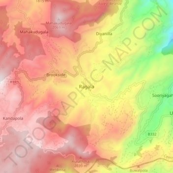
Name: Topografische Karte Ragala, Höhe, Relief.
Ort: Ragala, Nuwara Eliya District, Central Province, Sri Lanka (6.97182 80.81731 7.05182 80.89731)
Durchschnittliche Höhe: 1.632 m
Minimale Höhe: 860 m
Maximale Höhe: 2.126 m
Andere topografische Karten
Klicken Sie auf eine Karte, um ihre Topografie, ihre Höhe und ihr Relief anzuzeigen.
Gammaduwa
Gammaduwa, Matale District, Central Province, Sri Lanka
Durchschnittliche Höhe: 839 m
Kandy
Kandy, Kandy District, Central Province, 20000, Sri Lanka
Durchschnittliche Höhe: 621 m
Gombaniya
Gombaniya, Matale District, Central Province, Sri Lanka
Durchschnittliche Höhe: 1.523 m
Poththapitiya
Poththapitiya, Kandy District, Central Province, 20300, Sri Lanka
Durchschnittliche Höhe: 544 m
Ukuwela
Ukuwela, Matale District, Central Province, 21300, Sri Lanka
Durchschnittliche Höhe: 483 m
Thalagune
Thalagune, Kandy District, Central Province, Sri Lanka
Durchschnittliche Höhe: 744 m
Polgolla
Polgolla, Kandy District, Central Province, 20250, Sri Lanka
Durchschnittliche Höhe: 472 m
Wellethota
Wellethota, Kandy District, Central Province, 20900, Sri Lanka
Durchschnittliche Höhe: 525 m
Hatharaliyadda
Hatharaliyadda, Kandy District, Central Province, Sri Lanka
Durchschnittliche Höhe: 314 m
Ulapane
Ulapane, Kandy District, Central Province, 20668, Sri Lanka
Durchschnittliche Höhe: 670 m
Hatton
Hatton, Nuwara Eliya District, Central Province, 22050, Sri Lanka
Durchschnittliche Höhe: 1.290 m
Udapussellawa
Udapussellawa, Nuwara Eliya District, Central Province, Sri Lanka
Durchschnittliche Höhe: 1.254 m
Nanuoya Wood Shop
Sri Lanka > Central Province > Embilmeegama
Nanuoya Wood Shop, Kiribathkumbura, Embilmeegama, Kandy District, Central Province, 20450, Sri Lanka
Durchschnittliche Höhe: 522 m
Hagala State
Hagala State, Kandy District, Central Province, Sri Lanka
Durchschnittliche Höhe: 1.050 m
Panwila
Panwila, Kandy District, Central Province, 20810, Sri Lanka
Durchschnittliche Höhe: 755 m
Pitawala Pathana
Pitawala Pathana, Matale District, Central Province, Sri Lanka
Durchschnittliche Höhe: 738 m
Bibila
Sri Lanka > Central Province > Naula
Bibila, Naula, Matale District, Central Province, Sri Lanka
Durchschnittliche Höhe: 383 m
Kadugannawa
Kadugannawa, Kandy District, Central Province, 20300, Sri Lanka
Durchschnittliche Höhe: 490 m
Mulgampola
Sri Lanka > Central Province > Kandy
Mulgampola, Kandy, Kandy District, Central Province, 32350, Sri Lanka
Durchschnittliche Höhe: 577 m
Kandy District
Kandy District, Central Province, Sri Lanka
Durchschnittliche Höhe: 733 m
Ambuluwaawa
Sri Lanka > Central Province > Rathmalkaduwa
Ambuluwaawa, Rathmalkaduwa, Kandy District, Central Province, 20500, Sri Lanka
Durchschnittliche Höhe: 636 m
Mahaweli River
Mahaweli River, Central Province, 20032, Sri Lanka
Durchschnittliche Höhe: 176 m
Hanguranketha
Hanguranketha, Nuwara Eliya District, Central Province, Sri Lanka
Durchschnittliche Höhe: 768 m
Nillambe
Nillambe, Kandy District, Central Province, 20418, Sri Lanka
Durchschnittliche Höhe: 736 m
Haliyadda
Sri Lanka > Central Province > Danture
Haliyadda, Danture, Kandy District, Central Province, 20300, Sri Lanka
Durchschnittliche Höhe: 540 m
Embilmeegama
Embilmeegama, Kandy District, Central Province, 20450, Sri Lanka
Durchschnittliche Höhe: 526 m
Ginigathhena
Ginigathhena, Nuwara Eliya District, Central Province, 20686, Sri Lanka
Durchschnittliche Höhe: 662 m
Kothmale
Kothmale, Nuwara Eliya District, Central Province, 20838, Sri Lanka
Durchschnittliche Höhe: 1.239 m
Pussellawa
Pussellawa, Kandy District, Central Province, 20544, Sri Lanka
Durchschnittliche Höhe: 985 m
MoonValley Estate
MoonValley Estate, Kandy District, Central Province, 20168, Sri Lanka
Durchschnittliche Höhe: 487 m
Mathurata
Mathurata, Nuwara Eliya District, Central Province, Sri Lanka
Durchschnittliche Höhe: 1.056 m
Galabawa
Galabawa, Kandy District, Central Province, Sri Lanka
Durchschnittliche Höhe: 241 m
Nuwara Eliya
Sri Lanka > Central Province > Nuwara Eliya
Nuwara Eliya, Nuwara Eliya District, Central Province, 22000, Sri Lanka
Durchschnittliche Höhe: 1.426 m
Nikawatawana
Nikawatawana, Matale District, Central Province, Sri Lanka
Durchschnittliche Höhe: 228 m
Dambulla
Dambulla, Matale District, Central Province, 21000, Sri Lanka
Durchschnittliche Höhe: 173 m
Meewathura
Meewathura, Kandy District, Central Province, 20400, Sri Lanka
Durchschnittliche Höhe: 541 m
Pallepola
Pallepola, Matale District, Central Province, Sri Lanka
Durchschnittliche Höhe: 419 m
Glenlyon
Sri Lanka > Central Province > Agarapathana
Glenlyon, Agarapathana, Nuwara Eliya District, Central Province, Sri Lanka
Durchschnittliche Höhe: 1.464 m
Nuwara Eliya District
Nuwara Eliya District, Central Province, Sri Lanka
Durchschnittliche Höhe: 1.093 m
Maningamuwa
Maningamuwa, Matale District, Central Province, Sri Lanka
Durchschnittliche Höhe: 460 m
Halloluwa
Halloluwa, Kandy District, Central Province, 32350, Sri Lanka
Durchschnittliche Höhe: 522 m
Norton Bridge
Norton Bridge, Nuwara Eliya District, Central Province, 20686, Sri Lanka
Durchschnittliche Höhe: 1.011 m
Wanahapuwa
Sri Lanka > Central Province > Delthota
Wanahapuwa, Delthota, Kandy District, Central Province, 20420, Sri Lanka
Durchschnittliche Höhe: 957 m
Kumbuk-kandanwela
Kumbuk-kandanwela, Matale District, Central Province, 21120, Sri Lanka
Durchschnittliche Höhe: 201 m
Hantana
Sri Lanka > Central Province > Kandy
Hantana, Kandy, Kandy District, Central Province, 85129, Sri Lanka
Durchschnittliche Höhe: 706 m
Haddon Hill
Sri Lanka > Central Province > Nuwara Eliya
Haddon Hill, Nuwara Eliya, Nuwara Eliya District, Central Province, 22200, Sri Lanka
Durchschnittliche Höhe: 1.968 m
Ramboda
Ramboda, Nuwara Eliya District, Central Province, 20838, Sri Lanka
Durchschnittliche Höhe: 1.254 m
Matale District
Matale District, Central Province, Sri Lanka
Durchschnittliche Höhe: 270 m
Aluthgama
Aluthgama, Matale District, Central Province, 21000, Sri Lanka
Durchschnittliche Höhe: 399 m
Galaha
Galaha, Kandy District, Central Province, 20420, Sri Lanka
Durchschnittliche Höhe: 888 m