
Vielen Dank für die Unterstützung dieser Website ❤️
Spenden
Spenden
Topografische Karte Pullikkanam
Klicken Sie auf die Karte, um die Höhe anzuzeigen.
Vielen Dank für die Unterstützung dieser Website ❤️
Spenden
Spenden
Über diese Karte
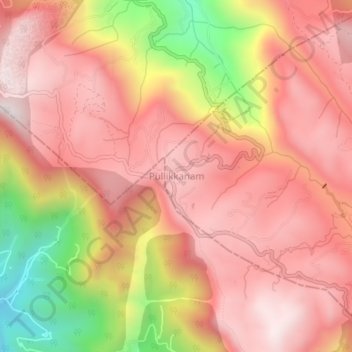
Name: Topografische Karte Pullikkanam, Höhe, Relief.
Ort: Pullikkanam, Peerumade, Idukki, Kerala, India (9.71328 76.84801 9.75328 76.88801)
Durchschnittliche Höhe: 740 m
Minimale Höhe: 147 m
Maximale Höhe: 1.042 m
Vielen Dank für die Unterstützung dieser Website ❤️
Spenden
Spenden
Andere topografische Karten
Klicken Sie auf eine Karte, um ihre Topografie, ihre Höhe und ihr Relief anzuzeigen.
Periyar National Park Tiger Reserve
Periyar National Park lies in the middle of a mountainous area of the Cardamom Hills. In the north : The boundary commences from the point nearest to the Medaganam in the interstate boundary up to Vellimalai. and the east Thence the boundary follows the inter-state boundary from Vellimalai to Kallimalai Peak…
Durchschnittliche Höhe: 929 m
Vielen Dank für die Unterstützung dieser Website ❤️
Spenden
Spenden