Geolokalisieren
👉 Easily get elevation data in JSON, GeoTIFF and KML formats using Elevation API
Vielen Dank für die Unterstützung dieser Website ❤️
Spenden

Topografische Karte Quintandona

Klicken Sie auf die Karte, um die Höhe anzuzeigen.

👉 Easily get elevation data in JSON, GeoTIFF and KML formats using Elevation API
Vielen Dank für die Unterstützung dieser Website ❤️
Spenden

Über diese Karte

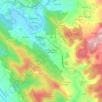
Name: Topografische Karte Quintandona, Höhe, Relief.

Ort: Quintandona, Lagares e Figueira, Penafiel, Porto, 4585-646, Portugal (41.11366 -8.39955 41.15366 -8.35955)

Durchschnittliche Höhe: 181 m

Minimale Höhe: 76 m

Maximale Höhe: 324 m

👉 Easily get elevation data in JSON, GeoTIFF and KML formats using Elevation API
Vielen Dank für die Unterstützung dieser Website ❤️
Spenden

Andere topografische Karten

Klicken Sie auf eine Karte, um ihre Topografie, ihre Höhe und ihr Relief anzuzeigen.

Abragão

Portugal > Porto > Penafiel

Durchschnittliche Höhe: 262 m

Galegos

Portugal > Porto > Penafiel

Durchschnittliche Höhe: 286 m

Lagares

Portugal > Porto > Penafiel

Durchschnittliche Höhe: 223 m

Galegos

Portugal > Porto > Penafiel

Durchschnittliche Höhe: 246 m

Vielen Dank für die Unterstützung dieser Website ❤️
Spenden

Parque do Sameiro

Portugal > Porto > Penafiel

Durchschnittliche Höhe: 294 m

Urrô

Portugal > Porto > Penafiel

Durchschnittliche Höhe: 159 m

Irivo

Portugal > Porto > Penafiel

Durchschnittliche Höhe: 180 m

Duas Igrejas

Portugal > Porto > Penafiel

Durchschnittliche Höhe: 376 m

Vielen Dank für die Unterstützung dieser Website ❤️
Spenden

Croca

Portugal > Porto > Penafiel

Durchschnittliche Höhe: 380 m

Boelhe

Portugal > Porto > Penafiel

Durchschnittliche Höhe: 199 m

Perozelo

Portugal > Porto > Penafiel

Durchschnittliche Höhe: 342 m

Recezinhos (São Mamede)

Portugal > Porto > Penafiel

Durchschnittliche Höhe: 293 m

Vielen Dank für die Unterstützung dieser Website ❤️
Spenden

Novelas

Portugal > Porto > Penafiel

Durchschnittliche Höhe: 195 m

Termas de São Vicente

Portugal > Porto > Penafiel

Durchschnittliche Höhe: 250 m

Penafiel

Portugal > Porto > Penafiel

Durchschnittliche Höhe: 240 m

Rio Cavalum

Portugal > Porto > Penafiel

Durchschnittliche Höhe: 287 m

Vielen Dank für die Unterstützung dieser Website ❤️
Spenden

Rans

Portugal > Porto > Penafiel

Durchschnittliche Höhe: 255 m

Capela

Portugal > Porto > Penafiel

Durchschnittliche Höhe: 320 m

Oldrões

Portugal > Porto > Penafiel

Durchschnittliche Höhe: 266 m

Cabeça Santa

Portugal > Porto > Penafiel

Durchschnittliche Höhe: 257 m

Vielen Dank für die Unterstützung dieser Website ❤️
Spenden

Guilhufe

Portugal > Porto > Penafiel

Durchschnittliche Höhe: 191 m

Fonte Arcada

Portugal > Porto > Penafiel

Durchschnittliche Höhe: 211 m

Lagares e Figueira

Portugal > Porto > Penafiel

Durchschnittliche Höhe: 270 m

Marecos

Portugal > Porto > Penafiel

Durchschnittliche Höhe: 280 m

Vielen Dank für die Unterstützung dieser Website ❤️
Spenden

Rio de Moinhos

Portugal > Porto > Penafiel

Durchschnittliche Höhe: 197 m

Pinheiro

Portugal > Porto > Penafiel

Durchschnittliche Höhe: 293 m

Valpedre

Portugal > Porto > Penafiel

Durchschnittliche Höhe: 284 m

Castelões

Portugal > Porto > Penafiel

Durchschnittliche Höhe: 200 m

Vielen Dank für die Unterstützung dieser Website ❤️
Spenden

Santiago de Subarrifana

Portugal > Porto > Penafiel

Durchschnittliche Höhe: 179 m

Sebolido

Portugal > Porto > Penafiel

Conquanto o povoamento do território desta freguesia seja muito anterior à nacionalidade (respeitam-lhe diretamente diplomas do século XII, e há alusões às vizinhanças, Canelas etc. - muito anteriores), a sua elevação à categoria de freguesia é relativamente moderna, não vai além de dois séculos,…

Durchschnittliche Höhe: 201 m

Luzim e Vila Cova

Portugal > Porto > Penafiel

Durchschnittliche Höhe: 332 m

Paço de Sousa

Portugal > Porto > Penafiel

Durchschnittliche Höhe: 203 m

Vielen Dank für die Unterstützung dieser Website ❤️
Spenden

Bustelo

Portugal > Porto > Penafiel

Durchschnittliche Höhe: 262 m