Geolokalisieren
👉 Easily get elevation data in JSON, GeoTIFF and KML formats using Elevation API
Vielen Dank für die Unterstützung dieser Website ❤️
Spenden

Topografische Karte Satyamangalam

Klicken Sie auf die Karte, um die Höhe anzuzeigen.

👉 Easily get elevation data in JSON, GeoTIFF and KML formats using Elevation API
Vielen Dank für die Unterstützung dieser Website ❤️
Spenden

Satyamangalam

Sathyamangalam is situated on the southern side of the Western Ghats, which extend towards the east from the Nilgiri mountains. The general topography is not flat and covered by sloping lands. Bhavani river flows at the center of the town from west to east. Agricultural wet lands are predominant on both sides of the river and dry lands are predominant on the northern side of the town. The soil mainly consists of black loam, red loam and red sand.

Wikipedia (CC-BY-SA 3.0)

👉 Easily get elevation data in JSON, GeoTIFF and KML formats using Elevation API
Vielen Dank für die Unterstützung dieser Website ❤️
Spenden

Über diese Karte

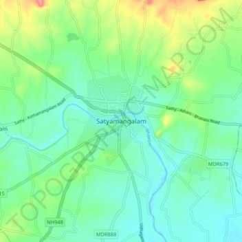
Name: Topografische Karte Satyamangalam, Höhe, Relief.

Ort: Satyamangalam, Sathyamangalam, Erode District, Tamil Nadu, 638401, India (11.46108 77.20514 11.54108 77.28514)

Durchschnittliche Höhe: 248 m

Minimale Höhe: 224 m

Maximale Höhe: 310 m

👉 Easily get elevation data in JSON, GeoTIFF and KML formats using Elevation API
Vielen Dank für die Unterstützung dieser Website ❤️
Spenden

Andere topografische Karten

Klicken Sie auf eine Karte, um ihre Topografie, ihre Höhe und ihr Relief anzuzeigen.

Perumpallam dam

India > Tamil Nadu > Sathyamangalam

Durchschnittliche Höhe: 335 m

Bhavanisagar Lake

India > Tamil Nadu > Sathyamangalam > Pungar

Durchschnittliche Höhe: 349 m