
Topografische Karte Cheltenham
Klicken Sie auf die Karte, um die Höhe anzuzeigen.
Über diese Karte
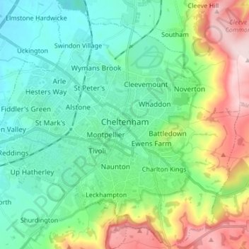
Name: Topografische Karte Cheltenham, Höhe, Relief.
Ort: Cheltenham, Gloucestershire, England, United Kingdom (51.85833 -2.14304 51.93887 -2.01022)
Durchschnittliche Höhe: 109 m
Minimale Höhe: 22 m
Maximale Höhe: 329 m
Andere topografische Karten
Klicken Sie auf eine Karte, um ihre Topografie, ihre Höhe und ihr Relief anzuzeigen.
Stow-on-the-Wold
United Kingdom > England > Gloucestershire > Cotswold District
Durchschnittliche Höhe: 163 m
Northleach
United Kingdom > England > Gloucestershire > Cotswold District
Durchschnittliche Höhe: 179 m
Chedworth
United Kingdom > England > Gloucestershire > Cotswold District
Durchschnittliche Höhe: 199 m
Tutnalls
United Kingdom > England > Gloucestershire > Forest of Dean > Lydney
Durchschnittliche Höhe: 31 m
Horcott Hill
United Kingdom > England > Gloucestershire > Cotswold District
Durchschnittliche Höhe: 86 m
Joyford
United Kingdom > England > Gloucestershire > Forest of Dean > Berry Hill
Durchschnittliche Höhe: 188 m
Jubilee Playing Field & Athletics Track
United Kingdom > England > Gloucestershire > Stroud > Cam > Draycott
Durchschnittliche Höhe: 45 m
Duntisbourne Abbots
United Kingdom > England > Gloucestershire > Cotswold District
Durchschnittliche Höhe: 204 m
Bishops Cleeve
United Kingdom > England > Gloucestershire > Bishop's Cleeve
Durchschnittliche Höhe: 91 m
Lower Slaughter
United Kingdom > England > Gloucestershire > Cotswold District
Durchschnittliche Höhe: 160 m
Condicote
United Kingdom > England > Gloucestershire > Cotswold District
Durchschnittliche Höhe: 201 m
Bream Meend
United Kingdom > England > Gloucestershire > Forest of Dean > Bream
Durchschnittliche Höhe: 140 m
Highbury
United Kingdom > England > Gloucestershire > Forest of Dean > Lydney > Allaston
Durchschnittliche Höhe: 65 m
Grange Village
United Kingdom > England > Gloucestershire > Forest of Dean > Littledean
Durchschnittliche Höhe: 98 m
Calcot
United Kingdom > England > Gloucestershire > Cotswold District > Coln Rogers
Durchschnittliche Höhe: 151 m
Bamfurlong
United Kingdom > England > Gloucestershire > Tewkesbury > Staverton
Durchschnittliche Höhe: 34 m
Christchurch
United Kingdom > England > Gloucestershire > Forest of Dean
Durchschnittliche Höhe: 182 m
Saunders Green
United Kingdom > England > Gloucestershire > Forest of Dean > Whitecroft
Durchschnittliche Höhe: 111 m
Bakers Hill
United Kingdom > England > Gloucestershire > Forest of Dean > Broadwell
Durchschnittliche Höhe: 195 m
Lydney Hub
United Kingdom > England > Gloucestershire > Forest of Dean > Lydney > Allaston > Tutnalls
Durchschnittliche Höhe: 42 m
Caudle Green
United Kingdom > England > Gloucestershire > Cotswold District > Brimpsfield
Durchschnittliche Höhe: 234 m
Chalford Hill
United Kingdom > England > Gloucestershire > Stroud > Chalford
Durchschnittliche Höhe: 175 m
Newent Woods
United Kingdom > England > Gloucestershire > Forest of Dean > May Hill
Durchschnittliche Höhe: 157 m
Ham
United Kingdom > England > Gloucestershire > Cheltenham > Cheltenham > Charlton Kings
Durchschnittliche Höhe: 140 m
Bourton-on-the-Hill
United Kingdom > England > Gloucestershire > Cotswold District
Durchschnittliche Höhe: 196 m
The Lake
United Kingdom > England > Gloucestershire > Cotswold > Upper Slaughter
Durchschnittliche Höhe: 198 m
Alney Island
United Kingdom > England > Gloucestershire > Tewkesbury > Maisemore
Durchschnittliche Höhe: 13 m
Sling
United Kingdom > England > Gloucestershire > Forest of Dean District
Durchschnittliche Höhe: 174 m
Hidcote Bartrim
United Kingdom > England > Gloucestershire > Cotswold District > Ebrington
Durchschnittliche Höhe: 148 m
Down Ampney
United Kingdom > England > Gloucestershire > Cotswold District
Durchschnittliche Höhe: 85 m
Westcote
United Kingdom > England > Gloucestershire > Cotswold > Westcote
Durchschnittliche Höhe: 178 m
The Pludds
United Kingdom > England > Gloucestershire > Forest of Dean > Ruardean
Durchschnittliche Höhe: 170 m
Brockhampton
United Kingdom > England > Gloucestershire > Bishop's Cleeve
Durchschnittliche Höhe: 44 m
Joys Green
United Kingdom > England > Gloucestershire > Forest of Dean > Upper Lydbrook
Durchschnittliche Höhe: 142 m
Bushley Muzzard, Brimpsfield
United Kingdom > England > Gloucestershire > Cotswold District > Nettleton > Watercombe
Durchschnittliche Höhe: 261 m
Southrop
United Kingdom > England > Gloucestershire > Cotswold > Southrop
Durchschnittliche Höhe: 98 m
Abbeymead Contour Park
United Kingdom > England > Gloucestershire > Gloucester
Durchschnittliche Höhe: 46 m
Ampney Crucis
United Kingdom > England > Gloucestershire > Cotswold District
Durchschnittliche Höhe: 114 m
Westbury-on-Severn
United Kingdom > England > Gloucestershire > Forest of Dean District
Durchschnittliche Höhe: 17 m
Hardwicke
United Kingdom > England > Gloucestershire > Stroud > Hardwicke
Durchschnittliche Höhe: 21 m
Wigpool Green
United Kingdom > England > Gloucestershire > Forest of Dean District > Puddlebrook > Wigpool Green
Durchschnittliche Höhe: 173 m
Millend
United Kingdom > England > Gloucestershire > Stroud > North Nibley
Durchschnittliche Höhe: 122 m
Dursley Cross
United Kingdom > England > Gloucestershire > Forest of Dean District > May Hill > Dursley Cross
Durchschnittliche Höhe: 126 m
Ruardean Hill
United Kingdom > England > Gloucestershire > Forest of Dean > Drybrook
Durchschnittliche Höhe: 204 m
Weston-sub-Edge
United Kingdom > England > Gloucestershire > Cotswold District
Durchschnittliche Höhe: 98 m
Upper Soudley
United Kingdom > England > Gloucestershire > Forest of Dean
Durchschnittliche Höhe: 138 m
Broad Campden
United Kingdom > England > Gloucestershire > Cotswold District
Durchschnittliche Höhe: 167 m
Knap House Quarry, Birdlip
United Kingdom > England > Gloucestershire > Cotswold District > Birdlip
Durchschnittliche Höhe: 222 m