
Topografische Karte The Buttes
Interaktive Karte
Klicken Sie auf die Karte, um die Höhe anzuzeigen.
Über diese Karte
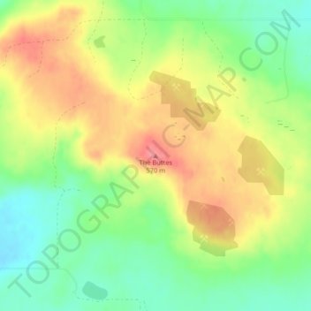
Name: Topografische Karte The Buttes, Höhe, Relief.
Durchschnittliche Höhe: 529 m
Minimale Höhe: 491 m
Maximale Höhe: 569 m
Andere topografische Karten
Klicken Sie auf eine Karte, um ihre Topografie, ihre Höhe und ihr Relief anzuzeigen.
New England
United States of America > North Dakota > New England
New England, Hettinger County, North Dakota, 58647, United States of America
Durchschnittliche Höhe: 793 m
Leith
United States of America > North Dakota > Leith
Leith, Grant County, North Dakota, United States of America
Durchschnittliche Höhe: 714 m
Drake
United States of America > North Dakota > Drake
Drake, McHenry County, North Dakota, United States of America
Durchschnittliche Höhe: 500 m
Grenora
United States of America > North Dakota > Grenora
Grenora, Williams County, North Dakota, United States of America
Durchschnittliche Höhe: 640 m
Hickson
United States of America > North Dakota > Hickson
Hickson, Cass County, North Dakota, United States of America
Durchschnittliche Höhe: 280 m