
Topografische Karte Merrivale
Interaktive Karte
Klicken Sie auf die Karte, um die Höhe anzuzeigen.
Über diese Karte
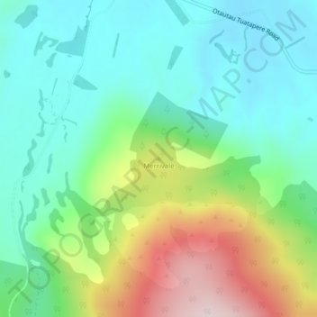
Name: Topografische Karte Merrivale, Höhe, Relief.
Durchschnittliche Höhe: 192 m
Minimale Höhe: 69 m
Maximale Höhe: 469 m
Andere topografische Karten
Klicken Sie auf eine Karte, um ihre Topografie, ihre Höhe und ihr Relief anzuzeigen.
The Downs
New Zealand > Southland > Southland District > Tuatapere Te Waewae Community
The Downs, Tuatapere Te Waewae Community, Southland District, Southland, New Zealand
Durchschnittliche Höhe: 34 m
White Peak
New Zealand > Southland > Southland District > Tuatapere Te Waewae Community
White Peak, Tuatapere Te Waewae Community, Southland District, Southland, New Zealand
Durchschnittliche Höhe: 1.153 m
Blackmount
New Zealand > Southland > Southland District > Tuatapere Te Waewae Community > Blackmount
Blackmount, Tuatapere Te Waewae Community, Southland District, Southland, New Zealand
Durchschnittliche Höhe: 170 m