
Topografische Karte Marktgemeinde Fulpmes
Interaktive Karte
Klicken Sie auf die Karte, um die Höhe anzuzeigen.
Über diese Karte
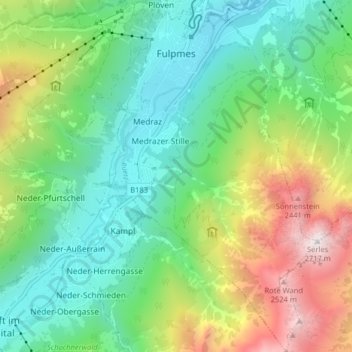
Name: Topografische Karte Marktgemeinde Fulpmes, Höhe, Relief.
Durchschnittliche Höhe: 1.451 m
Minimale Höhe: 875 m
Maximale Höhe: 2.685 m
The municipality of Fulpmes belongs to the Innsbruck Land district. It has an area of 16.77 square kilometres (6.47 sq mi), and an altitude of 936 metres (3,070 ft). The neighboring municipalities are Neustift to the west and Telfes and Mieders to the east. Fulpmes is the terminal station of the narrow-gauge railway Stubaitalbahn from Innsbruck.
Andere topografische Karten
Klicken Sie auf eine Karte, um ihre Topografie, ihre Höhe und ihr Relief anzuzeigen.
Leutasch
Austria > Tyrol > Bezirk Innsbruck-Land
Leutasch, Bezirk Innsbruck-Land, Tyrol, 6105, Austria
Durchschnittliche Höhe: 1.461 m
Gries am Brenner
Austria > Tyrol > Bezirk Innsbruck-Land
Gries am Brenner, Bezirk Innsbruck-Land, Tyrol, 6156, Austria
Durchschnittliche Höhe: 1.747 m
Gemeinde Sistrans
Austria > Tyrol > Bezirk Innsbruck-Land
Gemeinde Sistrans, Bezirk Innsbruck-Land, Tyrol, 6073, Austria
Durchschnittliche Höhe: 1.224 m
Gemeinde Gnadenwald
Austria > Tyrol > Bezirk Innsbruck-Land
Gemeinde Gnadenwald, Bezirk Innsbruck-Land, Tyrol, 6069, Austria
Durchschnittliche Höhe: 1.277 m
Mösern
Austria > Tyrol > Bezirk Innsbruck-Land > Marktgemeinde Telfs
Mösern, Marktgemeinde Telfs, Bezirk Innsbruck-Land, Tyrol, 6408, Austria
Durchschnittliche Höhe: 1.100 m
Gemeinde Axams
Austria > Tyrol > Bezirk Innsbruck-Land
Gemeinde Axams, Bezirk Innsbruck-Land, Tyrol, 6094, Austria
Durchschnittliche Höhe: 1.449 m
Gemeinde Wattenberg
Austria > Tyrol > Bezirk Innsbruck-Land
Gemeinde Wattenberg, Bezirk Innsbruck-Land, Tyrol, 6113, Austria
Durchschnittliche Höhe: 1.813 m
Marktgemeinde Telfs
Austria > Tyrol > Bezirk Innsbruck-Land
Marktgemeinde Telfs, Bezirk Innsbruck-Land, Tyrol, 6410, Austria
Durchschnittliche Höhe: 1.162 m
Gurgl
Austria > Tyrol > Bezirk Innsbruck-Land > Gemeinde Leutasch
Gurgl, Gemeinde Leutasch, Bezirk Innsbruck-Land, Tyrol, 6105, Austria
Durchschnittliche Höhe: 1.604 m
Glättebach
Austria > Tyrol > Bezirk Innsbruck-Land > Gemeinde Gschnitz
Glättebach, Gemeinde Gschnitz, Bezirk Innsbruck-Land, Tyrol, 6150, Austria
Durchschnittliche Höhe: 2.019 m
Axamer Lizum
Austria > Tyrol > Bezirk Innsbruck-Land > Gemeinde Axams > Axamer Lizum
Axamer Lizum, Gemeinde Axams, Bezirk Innsbruck-Land, Tyrol, 6092, Austria
Durchschnittliche Höhe: 1.858 m
Gemeinde Navis
Austria > Tyrol > Bezirk Innsbruck-Land > Gemeinde Navis
Gemeinde Navis, Bezirk Innsbruck-Land, Tyrol, 6145, Austria
Durchschnittliche Höhe: 1.898 m
Gemeinde Seefeld in Tirol
Austria > Tyrol > Bezirk Innsbruck-Land
Gemeinde Seefeld in Tirol, Bezirk Innsbruck-Land, Tyrol, 6100, Austria
Durchschnittliche Höhe: 1.303 m