
Spenden
Topografische Karte Waterville
Klicken Sie auf die Karte, um die Höhe anzuzeigen.
Spenden
Über diese Karte
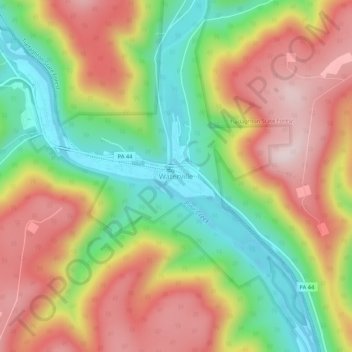
Name: Topografische Karte Waterville, Höhe, Relief.
Ort: Waterville, Lycoming County, Pennsylvania, United States (41.28851 -77.38201 41.32851 -77.34201)
Durchschnittliche Höhe: 390 m
Minimale Höhe: 173 m
Maximale Höhe: 616 m
Spenden
Andere topografische Karten
Klicken Sie auf eine Karte, um ihre Topografie, ihre Höhe und ihr Relief anzuzeigen.
Spenden
Cascade Township
United States > Pennsylvania > Lycoming County
According to the United States Census Bureau, the township has a total area of 39.5 square miles (102.4 km2), of which 39.2 square miles (101.5 km2) are land and 0.3 square miles (0.8 km2), or 0.81%, are water. The northern part of the township drains to Pleasant Stream, which flows west to join Lycoming Creek…
Durchschnittliche Höhe: 459 m
Brandon Park
United States > Pennsylvania > Lycoming County > Williamsport
Durchschnittliche Höhe: 179 m
Spenden
Spenden
McHenry Township
United States > Pennsylvania > Lycoming County
According to the United States Census Bureau, the township has a total area of 76.7 square miles (198.6 km2), of which 76.2 square miles (197.4 km2) are land and 0.46 square miles (1.2 km2), or 0.62%, are water. Pine Creek runs through the center of the township at the bottom of Pine Creek Gorge, with creek…
Durchschnittliche Höhe: 506 m
Cascade Township
United States > Pennsylvania > Lycoming County
According to the United States Census Bureau, the township has a total area of 39.5 square miles (102.4 km2), of which 39.2 square miles (101.5 km2) are land and 0.3 square miles (0.8 km2), or 0.81%, are water. The northern part of the township drains to Pleasant Stream, which flows west to join Lycoming Creek…
Durchschnittliche Höhe: 459 m
Spenden
Spenden
Hughesville
United States > Pennsylvania > Lycoming County > Hughesville
Durchschnittliche Höhe: 182 m