
Topografische Karte Pulford
Klicken Sie auf die Karte, um die Höhe anzuzeigen.
Über diese Karte
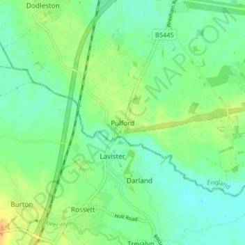
Name: Topografische Karte Pulford, Höhe, Relief.
Durchschnittliche Höhe: 15 m
Minimale Höhe: 4 m
Maximale Höhe: 31 m
Andere topografische Karten
Klicken Sie auf eine Karte, um ihre Topografie, ihre Höhe und ihr Relief anzuzeigen.
Great Boughton
United Kingdom > England > Cheshire West and Chester > Great Boughton
Durchschnittliche Höhe: 28 m
Countess of Chester Country Park
United Kingdom > England > Cheshire West and Chester > Chester
Durchschnittliche Höhe: 21 m
Burwardsley
United Kingdom > England > Cheshire West and Chester > Burwardsley
Durchschnittliche Höhe: 113 m
Frodsham
United Kingdom > England > Cheshire West and Chester
Several faults run roughly northwest–southeast through the area, notably the Overton Fault, which roughly parallels the B5439 and B5152 roads, and the Frodsham Fault, which runs north from the vicinity of Crowmere to the mouth of the River Weaver. Both of these faults and others in the area downthrow to the…
Durchschnittliche Höhe: 49 m
River Mersey
United Kingdom > England > Cheshire West and Chester > Bromborough
Durchschnittliche Höhe: 8 m
Capenhurst
United Kingdom > England > Cheshire West and Chester > Capenhurst
Durchschnittliche Höhe: 40 m
Bolesworth Fish Pond
United Kingdom > England > Cheshire West and Chester > Harthill > Broxton
Durchschnittliche Höhe: 75 m
Wirral Country Park
United Kingdom > England > Cheshire West and Chester > Neston > Windle Hill
Durchschnittliche Höhe: 49 m
Beeston Castle
United Kingdom > England > Cheshire West and Chester > Beeston
Durchschnittliche Höhe: 60 m
Peckforton Castle
United Kingdom > England > Cheshire West and Chester > Beeston
Peckforton Castle stands in a wooded area near the northern extremity of Peckforton Hills at an elevation of 469.2 feet (143 m). The land falls steeply downwards to the north and the west of the castle, and the Sandstone Trail, a long-distance footpath, runs along the base of these slopes. The ruins of Beeston…
Durchschnittliche Höhe: 83 m
Little Stanney
United Kingdom > England > Cheshire West and Chester > Ellesmere Port
Durchschnittliche Höhe: 21 m
Dutton Small Lock (Disused)
United Kingdom > England > Cheshire West and Chester > Acton Bridge > Dutton
Durchschnittliche Höhe: 28 m
Little Leigh
United Kingdom > England > Cheshire West and Chester > Little Leigh
Durchschnittliche Höhe: 38 m
Willington
United Kingdom > England > Cheshire West and Chester > Willington
Durchschnittliche Höhe: 86 m
Ness Wood
United Kingdom > England > Cheshire West and Chester > Neston > Ness
Durchschnittliche Höhe: 53 m
Roman Fort
United Kingdom > England > Cheshire West and Chester > Chester
Durchschnittliche Höhe: 21 m
Christleton
United Kingdom > England > Cheshire West and Chester > Brown Heath
Durchschnittliche Höhe: 29 m
Chester Castle
United Kingdom > England > Cheshire West and Chester > Chester
Durchschnittliche Höhe: 18 m
Black Diamond Park
United Kingdom > England > Cheshire West and Chester > Chester
Durchschnittliche Höhe: 21 m