
Spenden
Topografische Karte Tsimkoura
Klicken Sie auf die Karte, um die Höhe anzuzeigen.
Spenden
Über diese Karte
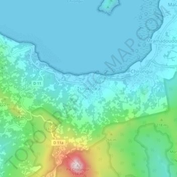
Name: Topografische Karte Tsimkoura, Höhe, Relief.
Ort: Tsimkoura, Chirongui, Mayotte, 97620, France (-12.95939 45.11689 -12.91939 45.15689)
Durchschnittliche Höhe: 93 m
Minimale Höhe: 0 m
Maximale Höhe: 504 m
Spenden
Andere topografische Karten
Klicken Sie auf eine Karte, um ihre Topografie, ihre Höhe und ihr Relief anzuzeigen.
Mtsamboro
The village of Mtsamboro lies on the northwest coast of the island along National Road 1. To the northeast is the village of Mtsahara and to the southwest is Mtsangadoua. Two small peninsulas jut out in the village area, the larger of which lies roughly a mile north of the village centre and separates the main…
Durchschnittliche Höhe: 48 m
Spenden
Spenden
Spenden
Bandraboua (canton de Mtsamboro)
France > Mayotte > Bandraboua > M'Tsangamboua
Durchschnittliche Höhe: 102 m