
Vielen Dank für die Unterstützung dieser Website ❤️
Spenden
Spenden
Topografische Karte Tackaberry Lake
Klicken Sie auf die Karte, um die Höhe anzuzeigen.
Vielen Dank für die Unterstützung dieser Website ❤️
Spenden
Spenden
Über diese Karte
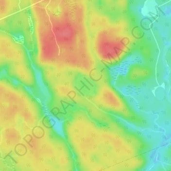
Name: Topografische Karte Tackaberry Lake, Höhe, Relief.
Durchschnittliche Höhe: 338 m
Minimale Höhe: 304 m
Maximale Höhe: 370 m
Vielen Dank für die Unterstützung dieser Website ❤️
Spenden
Spenden
Andere topografische Karten
Klicken Sie auf eine Karte, um ihre Topografie, ihre Höhe und ihr Relief anzuzeigen.
Lake of Bays
Canada > Ontario > Muskoka District > Lake of Bays Township
Durchschnittliche Höhe: 353 m
Limberlost Forest and Wildlife Reserve
Canada > Ontario > Muskoka District > Lake of Bays Township
Durchschnittliche Höhe: 400 m