
Topografische Karte Longview
Interaktive Karte
Klicken Sie auf die Karte, um die Höhe anzuzeigen.
Longview
Longview is located in a small gorge, so its climate varies from that of its close neighbor, Portland. Longview is generally about 7 °F (4 °C) cooler than Portland. Located about 80 miles (130 km) inland across a stretch of relatively flat ground, the Longview skies can be overcast due to moisture from the Pacific Coast marine layer. The Columbia River gorge permits an exchange of air between eastern and western Washington. The direction and speed of air movement through the gorge is determined primarily by the pressure gradient between the eastern and western slopes of the mountains. Due to the gorge-like effect, marine pushes on summer evenings can frequently reach gusts up to 30 to 40 miles per hour (48 to 64 km/h) There have been gusts of up to 90 to 100 miles per hour (140 to 160 km/h), and over 100 miles per hour (160 km/h) at higher elevations.
Über diese Karte
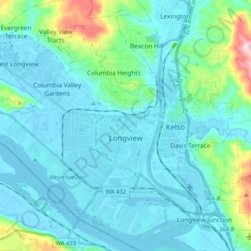
Name: Topografische Karte Longview, Höhe, Relief.
Ort: Longview, Cowlitz County, Washington, United States (46.10163 -123.03935 46.18358 -122.89177)
Durchschnittliche Höhe: 50 m
Minimale Höhe: -5 m
Maximale Höhe: 366 m