
Topografische Karte Brevard County
Interaktive Karte
Klicken Sie auf die Karte, um die Höhe anzuzeigen.
Über diese Karte
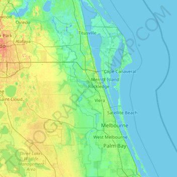
Name: Topografische Karte Brevard County, Höhe, Relief.
Ort: Brevard County, Florida, USA (27.82206 -80.98801 28.79140 -80.38507)
Durchschnittliche Höhe: 7 m
Minimale Höhe: -4 m
Maximale Höhe: 55 m
Andere topografische Karten
Klicken Sie auf eine Karte, um ihre Topografie, ihre Höhe und ihr Relief anzuzeigen.
Presbyterian Villas Of Lehigh
USA > Florida > Presbyterian Villas Of Lehigh
Presbyterian Villas Of Lehigh, Lee County, Florida, 33936, USA
Durchschnittliche Höhe: 10 m
Middle River
USA > Florida > Fort Lauderdale
Middle River, Fort Lauderdale, Broward County, Florida, 33305:33306, USA
Durchschnittliche Höhe: 6 m
Dawson Island
USA > Florida > Jacksonville
Dawson Island, Jacksonville, Duval County, Florida, USA
Durchschnittliche Höhe: 2 m
St. Augustine
USA > Florida > St. Augustine
St. Augustine, St. Johns County, Florida, 32084, USA
Durchschnittliche Höhe: 5 m
Tallahassee
USA > Florida > Tallahassee
Tallahassee, Leon County, Florida, USA
Durchschnittliche Höhe: 36 m
Pembroke Pines
USA > Florida > Pembroke Pines
Pembroke Pines, Broward County, Florida, USA
Durchschnittliche Höhe: 5 m
Altamonte Springs
USA > Florida > Altamonte Springs
Altamonte Springs, Seminole County, Florida, USA
Durchschnittliche Höhe: 26 m
The Villages
USA > Florida > The Villages
The Villages, Lake County, Florida, USA
Durchschnittliche Höhe: 27 m