
Topografische Karte Salacoa
Interaktive Karte
Klicken Sie auf die Karte, um die Höhe anzuzeigen.
Über diese Karte
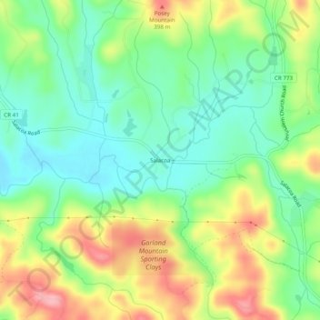
Name: Topografische Karte Salacoa, Höhe, Relief.
Ort: Salacoa, Cherokee County, Georgia, United States (34.37065 -84.63132 34.41065 -84.59132)
Durchschnittliche Höhe: 326 m
Minimale Höhe: 272 m
Maximale Höhe: 410 m
Andere topografische Karten
Klicken Sie auf eine Karte, um ihre Topografie, ihre Höhe und ihr Relief anzuzeigen.
Ball Ground
United States > Georgia > Cherokee County
Ball Ground, Cherokee County, Georgia, United States
Durchschnittliche Höhe: 331 m
North Canton
United States > Georgia > Cherokee County > Canton
North Canton, Canton, Cherokee County, Georgia, 30114, United States
Durchschnittliche Höhe: 292 m
Waleska
United States > Georgia > Cherokee County
Waleska, Cherokee County, Georgia, United States
Durchschnittliche Höhe: 335 m
Garland Mountain
United States > Georgia > Cherokee County
Garland Mountain, Cherokee County, Georgia, 30183, United States
Durchschnittliche Höhe: 379 m
Canton
United States > Georgia > Cherokee County
Canton, Cherokee County, Georgia, 30114, United States
Durchschnittliche Höhe: 320 m
Waleska
United States > Georgia > Cherokee County > Waleska
Waleska, Cherokee County, Georgia, 30183, United States
Durchschnittliche Höhe: 338 m
Woodstock
United States > Georgia > Cherokee County
Woodstock, Cherokee County, Georgia, United States
Durchschnittliche Höhe: 296 m