
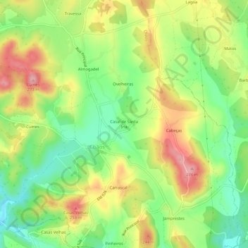
Topografische Karte Casal de Santa Iria
Interaktive Karte
Klicken Sie auf die Karte, um die Höhe anzuzeigen.
Über diese Karte
Name: Topografische Karte Casal de Santa Iria, Höhe, Relief.
Durchschnittliche Höhe: 192 m
Minimale Höhe: 129 m
Maximale Höhe: 267 m
Andere topografische Karten
Klicken Sie auf eine Karte, um ihre Topografie, ihre Höhe und ihr Relief anzuzeigen.
Portomar
Portugal > Santarém > Ferreira do Zêzere
Portomar, Ferreira do Zêzere, Santarém, 2240-350, Portugal
Durchschnittliche Höhe: 318 m
Igreja Nova do Sobral
Portugal > Santarém > Ferreira do Zêzere
Igreja Nova do Sobral, Ferreira do Zêzere, Santarém, Portugal
Durchschnittliche Höhe: 262 m
Lagar Velho
Portugal > Santarém > Ferreira do Zêzere
Lagar Velho, Ferreira do Zêzere, Santarém, 2240, Portugal
Durchschnittliche Höhe: 223 m
Carril
Portugal > Santarém > Ferreira do Zêzere
Carril, Nossa Senhora do Pranto, Ferreira do Zêzere, Santarém, 2240-612, Portugal
Durchschnittliche Höhe: 298 m
Mata
Portugal > Santarém > Ferreira do Zêzere
Mata, Águas Belas, Ferreira do Zêzere, Santarém, 2240-347, Portugal
Durchschnittliche Höhe: 312 m
Paio Mendes
Portugal > Santarém > Ferreira do Zêzere
Paio Mendes, Nossa Senhora do Pranto, Ferreira do Zêzere, Santarém, 2240-612, Portugal
Durchschnittliche Höhe: 299 m
Nossa Senhora do Pranto
Portugal > Santarém > Ferreira do Zêzere
Nossa Senhora do Pranto, Ferreira do Zêzere, Santarém, 2240-612, Portugal
Durchschnittliche Höhe: 253 m
Pias
Portugal > Santarém > Ferreira do Zêzere
Pias, Ferreira do Zêzere, Santarém, 2305-067, Portugal
Durchschnittliche Höhe: 256 m
Dornes
Portugal > Santarém > Ferreira do Zêzere
Dornes, Nossa Senhora do Pranto, Ferreira do Zêzere, Santarém, 2240-612, Portugal
Durchschnittliche Höhe: 224 m
Bairrada
Portugal > Santarém > Ferreira do Zêzere
Bairrada, Ferreira do Zêzere, Santarém, 2240-332, Portugal
Durchschnittliche Höhe: 172 m