
Topografische Karte Ashbourne CP
Interaktive Karte
Klicken Sie auf die Karte, um die Höhe anzuzeigen.
Über diese Karte
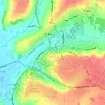
Name: Topografische Karte Ashbourne CP, Höhe, Relief.
Durchschnittliche Höhe: 147 m
Minimale Höhe: 112 m
Maximale Höhe: 187 m
Ashbourne lies at 53°01′N 01°44′W / 53.017°N 1.733°W / 53.017; -1.733. Ashbourne Green and Sturston are hamlets close by. Henmore Brook, a tributary of the River Dove, flows through the middle of the town. It has an elevation of 400 feet (122 m).
Andere topografische Karten
Klicken Sie auf eine Karte, um ihre Topografie, ihre Höhe und ihr Relief anzuzeigen.
Hathersage
United Kingdom > England > Derbyshire > Derbyshire Dales
Hathersage, Derbyshire Dales, Derbyshire, England, United Kingdom
Durchschnittliche Höhe: 311 m
Eyam CP
United Kingdom > England > Derbyshire > Derbyshire Dales
Eyam CP, Derbyshire Dales, Derbyshire, England, United Kingdom
Durchschnittliche Höhe: 280 m
Callow CP
United Kingdom > England > Derbyshire > Derbyshire Dales
Callow CP, Derbyshire Dales, Derbyshire, England, United Kingdom
Durchschnittliche Höhe: 203 m
Chelmorton CP
United Kingdom > England > Derbyshire > Derbyshire Dales > Chelmorton CP
Chelmorton CP, Derbyshire Dales, Derbyshire, England, United Kingdom
Durchschnittliche Höhe: 362 m
Yeaveley CP
United Kingdom > England > Derbyshire > Derbyshire Dales > Yeaveley CP
Yeaveley CP, Derbyshire Dales, Derbyshire, England, United Kingdom
Durchschnittliche Höhe: 148 m
Matlock
United Kingdom > England > Derbyshire > Derbyshire Dales > Matlock
Matlock, Derbyshire Dales, Derbyshire, East Midlands, England, DE4 3AP, United Kingdom
Durchschnittliche Höhe: 213 m