
Vielen Dank für die Unterstützung dieser Website ❤️
Spenden
Spenden
Topografische Karte Indaiatuba
Klicken Sie auf die Karte, um die Höhe anzuzeigen.
Vielen Dank für die Unterstützung dieser Website ❤️
Spenden
Spenden
Indaiatuba
Indaiatuba is a municipality in the state of São Paulo, Brazil. It is part of the Metropolitan Region of Campinas. The population is 256,223 (2020 est.) in an area of 311.5 km2 (120.3 sq mi). The elevation is 624 m (2,047 ft). The city's name derives from the Tupi language, which roughly translates to "gathering of palm trees". It is an important city in one of Brazil's main industrial regions.
Vielen Dank für die Unterstützung dieser Website ❤️
Spenden
Spenden
Über diese Karte
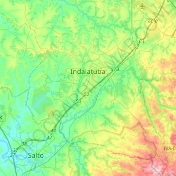
Name: Topografische Karte Indaiatuba, Höhe, Relief.
Durchschnittliche Höhe: 619 m
Minimale Höhe: 497 m
Maximale Höhe: 916 m
Vielen Dank für die Unterstützung dieser Website ❤️
Spenden
Spenden
Andere topografische Karten
Klicken Sie auf eine Karte, um ihre Topografie, ihre Höhe und ihr Relief anzuzeigen.
João Aranha
Brazil > São Paulo > Região Metropolitana de Campinas > Paulínia
Durchschnittliche Höhe: 583 m