
Topografische Karte Piscataway Park
Interaktive Karte
Klicken Sie auf die Karte, um die Höhe anzuzeigen.
Über diese Karte
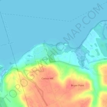
Name: Topografische Karte Piscataway Park, Höhe, Relief.
Durchschnittliche Höhe: 16 m
Minimale Höhe: -4 m
Maximale Höhe: 58 m
Andere topografische Karten
Klicken Sie auf eine Karte, um ihre Topografie, ihre Höhe und ihr Relief anzuzeigen.
Loch Raven Reservoir
Loch Raven Reservoir, Dulaney Valley Road, Towson, Baltimore County, Maryland, 21093, USA
Durchschnittliche Höhe: 113 m
Prettyboy Reservoir
USA > Maryland > Beckleysville
Prettyboy Reservoir, Gunpowder Road, Foreston Ridge Estates, Beckleysville, Baltimore County, Maryland, 21102, USA
Durchschnittliche Höhe: 202 m
Patterson Park
Patterson Park, Baltimore - Linwood, Baltimore, Maryland, USA
Durchschnittliche Höhe: 17 m
North Branch Potomac River
North Branch Potomac River, Allegany County, Maryland, 21502, USA
Durchschnittliche Höhe: 578 m
Deal Island
Deal Island, Somerset County, Maryland, 21821, USA
Durchschnittliche Höhe: 2 m
Fort Washington
Fort Washington, Ft Washington Pk Road, Riverview, Fort Washington, Prince George's County, Maryland, 22308, USA
Durchschnittliche Höhe: 11 m
Turkey Point
USA > Maryland > Turkey Point
Turkey Point, Baltimore County, Maryland, 21220-5203, USA
Durchschnittliche Höhe: 3 m
Marshy Point Nature Center
USA > Maryland > Bowleys Quarters
Marshy Point Nature Center, Chase, Bowleys Quarters, Baltimore County, Maryland, USA
Durchschnittliche Höhe: 5 m
Smithville Lake
Smithville Lake, Caroline County, Maryland, USA
Durchschnittliche Höhe: 11 m
Lake Habeeb
USA > Maryland > Pleasant Valley
Lake Habeeb, Lakeside Loop Trail, Pleasant Valley, Allegany County, Maryland, USA
Durchschnittliche Höhe: 426 m
Walden Farms
USA > Maryland > Walden Farms
Walden Farms, Carroll County, Maryland, USA
Durchschnittliche Höhe: 136 m
Nottinghamshire Farms
USA > Maryland > Nottinghamshire Farms
Nottinghamshire Farms, Baltimore County, Maryland, 21161, USA
Durchschnittliche Höhe: 189 m
Green Haven
USA > Maryland > Green Haven
Green Haven, Anne Arundel County, Maryland, USA
Durchschnittliche Höhe: 15 m
Greenwood Acres
USA > Maryland > Greenwood Acres
Greenwood Acres, Anne Arundel County, Maryland, 20776:21037, USA
Durchschnittliche Höhe: 25 m
Janes Island
Janes Island, Somerset County, Maryland, 21817, USA
Durchschnittliche Höhe: 2 m
Oregon Ridge Nature Center
Oregon Ridge Nature Center, Hunt Valley, Oregon, Baltimore County, Maryland, USA
Durchschnittliche Höhe: 154 m
Eden Hills
USA > Maryland > Eden Hills
Eden Hills, Harford County, Maryland, USA
Durchschnittliche Höhe: 139 m
Hoye-Crest
Hoye-Crest, Garrett County, Maryland, 26716, USA
Durchschnittliche Höhe: 887 m
Holland Island
Holland Island, Dorchester County, Maryland, USA
Durchschnittliche Höhe: 3 m
Joint Base Andrews
USA > Maryland > Joint Base Andrews
Joint Base Andrews, Prince George's County, Maryland, 20762, USA
Durchschnittliche Höhe: 79 m
South River
USA > Maryland > The Ridings
South River, Melvin Road, Robinwood, The Ridings, Anne Arundel County, Maryland, 21403, USA
Durchschnittliche Höhe: 10 m
Warrior Mountain
Warrior Mountain, Allegany County, Maryland, USA
Durchschnittliche Höhe: 509 m
Gwynns Falls Leakin Park
Gwynns Falls Leakin Park, Wakefield, Baltimore, Maryland, USA
Durchschnittliche Höhe: 98 m
Pocomoke River
Pocomoke River, Worcester County, Maryland, 21863, USA
Durchschnittliche Höhe: 7 m
Chapel Point
USA > Maryland > Chapel Point
Chapel Point, Charles County, Maryland, 20677, USA
Durchschnittliche Höhe: 16 m
Beverly Beach
USA > Maryland > Beverly Beach
Beverly Beach, Anne Arundel County, Maryland, 20764, USA
Durchschnittliche Höhe: 2 m
Robinson Nature Center
Robinson Nature Center, Sycamoer Stroll, La Isla, Hickory Ridge, Howard County, Maryland, 20723-6099, USA
Durchschnittliche Höhe: 112 m
New Germany State Park
USA > Maryland > New Germany
New Germany State Park, New Germany, Garrett County, Maryland, USA
Durchschnittliche Höhe: 799 m
Patuxent Wildlife Research Center - North Tract
Patuxent Wildlife Research Center - North Tract, Patuxent Road, Piney Orchard, Patuxent, Anne Arundel County, Maryland, 21112, USA
Durchschnittliche Höhe: 44 m
Cylburn Arboretum
Cylburn Arboretum, Cold Spring, Baltimore, Maryland, USA
Durchschnittliche Höhe: 104 m
Woodland Beach
USA > Maryland > Woodland Beach
Woodland Beach, Anne Arundel County, Maryland, 21122, USA
Durchschnittliche Höhe: 10 m
Eastern Neck Island
Eastern Neck Island, Kent County, Maryland, USA
Durchschnittliche Höhe: 10 m
Hemlock Gorge
USA > Maryland > Hoffmanville
Hemlock Gorge, Gunpowder Road, Hoffmanville, Baltimore County, Maryland, 21102, USA
Durchschnittliche Höhe: 217 m
North Laurel
USA > Maryland > North Laurel
North Laurel, Howard County, Maryland, 20723, USA
Durchschnittliche Höhe: 86 m
Sinepuxent Bay
USA > Maryland > Golf Club Shores
Sinepuxent Bay, Verrazano Bridge, Golf Club Shores, Worcester County, Maryland, 21811, USA
Durchschnittliche Höhe: 0 m
Hunting Hills
USA > Maryland > Hunting Hills
Hunting Hills, Calvert County, Maryland, 20639, USA
Durchschnittliche Höhe: 26 m
Twin Harbors
USA > Maryland > Twin Harbors
Twin Harbors, Anne Arundel County, Maryland, 21012, USA
Durchschnittliche Höhe: 11 m
Prospect Hill
Prospect Hill, Baltimore, Maryland, 21211, USA
Durchschnittliche Höhe: 85 m
Chelsea Beach
USA > Maryland > Chelsea Beach
Chelsea Beach, Anne Arundel County, Maryland, 21122, USA
Durchschnittliche Höhe: 12 m
Nanticoke River
Nanticoke River, Wicomico County, Maryland, 21861, USA
Durchschnittliche Höhe: 6 m