
Topografische Karte Dalhousie
Interaktive Karte
Klicken Sie auf die Karte, um die Höhe anzuzeigen.
Über diese Karte
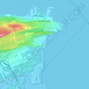
Name: Topografische Karte Dalhousie, Höhe, Relief.
Durchschnittliche Höhe: 15 m
Minimale Höhe: -3 m
Maximale Höhe: 191 m
Dalhousie is the most northern point in New Brunswick, and thus is in the Maritime provinces. It is situated in the Restigouche River valley at the tongue of the river where it discharges into Chaleur Bay. The valley lies in a hilly region, part of the Appalachian mountain range, although the Dalhousie town site is situated on a hill side several decameters above sea level with some development to its south on a low ridge of approximately 260 metres elevation. The town is surrounded by salt and fresh water bodies, which are home to many species of wildlife, unique birds, and fish. The area is rich in natural resources.
Andere topografische Karten
Klicken Sie auf eine Karte, um ihre Topografie, ihre Höhe und ihr Relief anzuzeigen.
Eel River Crossing
Canada > New Brunswick > Dalhousie Parish
Eel River Crossing, Dalhousie Parish, Restigouche County, New Brunswick, E8E 1S2, Canada
Durchschnittliche Höhe: 20 m