Geolokalisieren
👉 Easily get elevation data in JSON, GeoTIFF and KML formats using Elevation API
Vielen Dank für die Unterstützung dieser Website ❤️
Spenden

Topografische Karte Indang

Klicken Sie auf die Karte, um die Höhe anzuzeigen.

👉 Easily get elevation data in JSON, GeoTIFF and KML formats using Elevation API
Vielen Dank für die Unterstützung dieser Website ❤️
Spenden

Indang

The topography of Indang is characterised by gently sloping or rolling terrain. Almost 40.36% of its total land area is within the slope grade of 3-8%, while 2,135 hectares is within the slope range of 8-15% which is characterised by undulating or sloping terrain.

👉 Easily get elevation data in JSON, GeoTIFF and KML formats using Elevation API
Vielen Dank für die Unterstützung dieser Website ❤️
Spenden

Über diese Karte

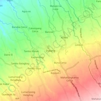
Name: Topografische Karte Indang, Höhe, Relief.

Ort: Indang, Cavite, Calabarzon, 4122, Philippines (14.15584 120.83838 14.23584 120.91838)

Durchschnittliche Höhe: 298 m

Minimale Höhe: 150 m

Maximale Höhe: 477 m

👉 Easily get elevation data in JSON, GeoTIFF and KML formats using Elevation API
Vielen Dank für die Unterstützung dieser Website ❤️
Spenden

Andere topografische Karten

Klicken Sie auf eine Karte, um ihre Topografie, ihre Höhe und ihr Relief anzuzeigen.

Bancod

Philippines > Cavite > Indang

Durchschnittliche Höhe: 241 m

Mataas na Lupa (Checkpoint)

Philippines > Cavite > Indang

Durchschnittliche Höhe: 225 m

Kaytapos

Philippines > Cavite > Indang

Durchschnittliche Höhe: 308 m

Mataas na Lupa (Checkpoint)

Philippines > Cavite > Indang

Durchschnittliche Höhe: 225 m

Vielen Dank für die Unterstützung dieser Website ❤️
Spenden