

Topografische Karte Sattler
Klicken Sie auf die Karte, um die Höhe anzuzeigen.
Über diese Karte
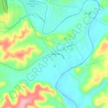
Name: Topografische Karte Sattler, Höhe, Relief.
Ort: Sattler, Comal County, Texas, United States (29.82800 -98.19557 29.86800 -98.15557)
Durchschnittliche Höhe: 265 m
Minimale Höhe: 222 m
Maximale Höhe: 364 m
Andere topografische Karten
Klicken Sie auf eine Karte, um ihre Topografie, ihre Höhe und ihr Relief anzuzeigen.
New Braunfels
United States > Texas > Comal County
New Braunfels occupies a transitional Hill Country setting on the Balcones Escarpment, where the higher, more dissected limestone uplands of the Edwards Plateau give way southeastward toward lower prairie terrain. The city’s relief is organized around the Guadalupe River valley and the short spring-fed Comal…
Durchschnittliche Höhe: 228 m


Bracken Cave Preserve
United States > Texas > Comal County > Garden Ridge
Durchschnittliche Höhe: 319 m

Comal River
United States > Texas > Comal County > New Braunfels > Landa Park Estates
Durchschnittliche Höhe: 197 m
Guadalupe River State Park
United States > Texas > Comal County > Spring Branch
Durchschnittliche Höhe: 353 m
New Braunfels
United States > Texas > Comal County
New Braunfels occupies a transitional Hill Country setting on the Balcones Escarpment, where the higher, more dissected limestone uplands of the Edwards Plateau give way southeastward toward lower prairie terrain. The city’s relief is organized around the Guadalupe River valley and the short spring-fed Comal…
Durchschnittliche Höhe: 228 m
Comal River
United States > Texas > Comal County > New Braunfels > Landa Park Estates
Durchschnittliche Höhe: 206 m
New Braunfels
United States > Texas > Comal County
New Braunfels occupies a transitional Hill Country setting on the Balcones Escarpment, where the higher, more dissected limestone uplands of the Edwards Plateau give way southeastward toward lower prairie terrain. The city’s relief is organized around the Guadalupe River valley and the short spring-fed Comal…
Durchschnittliche Höhe: 228 m