
Topografische Karte Preston
Klicken Sie auf die Karte, um die Höhe anzuzeigen.
Über diese Karte
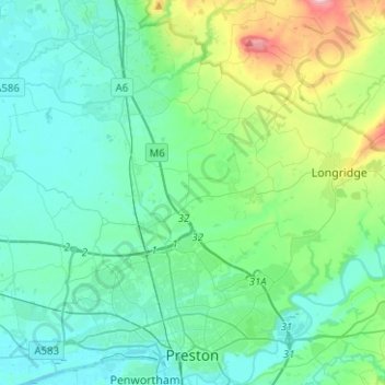
Name: Topografische Karte Preston, Höhe, Relief.
Ort: Preston, Lancashire, England, United Kingdom (53.74801 -2.82600 53.89615 -2.59544)
Durchschnittliche Höhe: 58 m
Minimale Höhe: 1 m
Maximale Höhe: 308 m
Andere topografische Karten
Klicken Sie auf eine Karte, um ihre Topografie, ihre Höhe und ihr Relief anzuzeigen.
Bacup
United Kingdom > England > Lancashire > Borough of Rossendale
The geology and topography of the village lent itself to urbanisation and domestic industries; primitive weavers' cottages, coal pits and stone quarries were propelled by Bacup's natural supply of water power in the Early Modern period. The adoption of the factory system, which developed into the Industrial…
Durchschnittliche Höhe: 337 m
Billington and Langho
United Kingdom > England > Lancashire > Ribble Valley > Brockhall Village
Durchschnittliche Höhe: 58 m
Old Langho
United Kingdom > England > Lancashire > Ribble Valley > Brockhall Village
Durchschnittliche Höhe: 74 m
Haslingden
United Kingdom > England > Lancashire > Borough of Rossendale
Durchschnittliche Höhe: 275 m
Rawtenstall
United Kingdom > England > Lancashire > Borough of Rossendale
Durchschnittliche Höhe: 284 m
Accrington
United Kingdom > England > Lancashire > Hyndburn
Geographical coordinates: 53° 46' 0" North, 2° 21' 0" West. Height above sea level: there is a spot height outside the Market Hall which is 133.5 metres (438 ft) the benchmark on the side of the neighbouring Town Hall is 441.10 feet (134.45 m). The highest height in the town is 320 metres (1,050 ft) which is…
Durchschnittliche Höhe: 199 m
Haslingden Grane
United Kingdom > England > Lancashire > Borough of Rossendale > Haslingden
Durchschnittliche Höhe: 287 m
Colne Water
United Kingdom > England > Lancashire > Borough of Pendle > Laneshaw Bridge
Durchschnittliche Höhe: 202 m
Silverdale Green
United Kingdom > England > Lancashire > Lancaster > Silverdale
Durchschnittliche Höhe: 24 m
Deeply Vale
United Kingdom > England > Lancashire > Borough of Rossendale
Durchschnittliche Höhe: 231 m
Haslingden Grane
United Kingdom > England > Lancashire > Borough of Rossendale
Durchschnittliche Höhe: 305 m
Brockholes Visitor Village
United Kingdom > England > Lancashire > Preston
Durchschnittliche Höhe: 32 m
Larbreck
United Kingdom > England > Lancashire > Borough of Fylde > Little Eccleston
Durchschnittliche Höhe: 12 m
The Viewpoint
United Kingdom > England > Lancashire > Chorley > Rivington
Durchschnittliche Höhe: 183 m
Whitechapel
United Kingdom > England > Lancashire > Preston > Whitechapel
Durchschnittliche Höhe: 123 m
Copp
United Kingdom > England > Lancashire > Wyre > Great Eccleston > Copp
Durchschnittliche Höhe: 13 m
Crossmoor
United Kingdom > England > Lancashire > Fylde > Elswick > Crossmoor
Durchschnittliche Höhe: 14 m
Holt Green
United Kingdom > England > Lancashire > West Lancashire > Aughton
Durchschnittliche Höhe: 35 m
Stacksteads
United Kingdom > England > Lancashire > Borough of Rossendale
Durchschnittliche Höhe: 306 m
St Michael's on Wyre
United Kingdom > England > Lancashire > Borough of Wyre
Durchschnittliche Höhe: 10 m
Whittle Springs
United Kingdom > England > Lancashire > Chorley > Wheelton
Durchschnittliche Höhe: 111 m
Rising Bridge
United Kingdom > England > Lancashire > Borough of Rossendale
Durchschnittliche Höhe: 281 m
Walton Summit
United Kingdom > England > Lancashire > South Ribble > Bamber Bridge
Durchschnittliche Höhe: 67 m
Lower Burrow
United Kingdom > England > Lancashire > Lancaster > Bailrigg
Durchschnittliche Höhe: 36 m
Irwell Springs
United Kingdom > England > Lancashire > Borough of Rossendale > Weir
Durchschnittliche Höhe: 365 m
Clowbridge
United Kingdom > England > Lancashire > Borough of Rossendale > Habergham Eaves
Durchschnittliche Höhe: 319 m
Ewood Bridge
United Kingdom > England > Lancashire > Borough of Rossendale
Durchschnittliche Höhe: 226 m
Warton Bank
United Kingdom > England > Lancashire > Borough of Fylde > Warton
Durchschnittliche Höhe: 8 m
Brungerley Park
United Kingdom > England > Lancashire > Ribble Valley > Clitheroe > Waddington
Durchschnittliche Höhe: 77 m
Whitewell Bottom
United Kingdom > England > Lancashire > Borough of Rossendale > Sagar Holme
Durchschnittliche Höhe: 281 m
Rivington Pike
United Kingdom > England > Lancashire > Chorley > Rivington
Durchschnittliche Höhe: 270 m
Lower Bartle
United Kingdom > England > Lancashire > Preston > Woodplumpton
Durchschnittliche Höhe: 30 m
Fold Head
United Kingdom > England > Lancashire > Borough of Rossendale > Healey
Durchschnittliche Höhe: 294 m
Catlow
United Kingdom > England > Lancashire > Borough of Pendle > Nelson
Durchschnittliche Höhe: 243 m
Trough Gate
United Kingdom > England > Lancashire > Borough of Rossendale > Britannia
Durchschnittliche Höhe: 341 m
Forest Holme
United Kingdom > England > Lancashire > Borough of Rossendale > Water
Durchschnittliche Höhe: 318 m
Scarth Hill
United Kingdom > England > Lancashire > West Lancashire > Ormskirk
Durchschnittliche Höhe: 58 m
Nun Hills
United Kingdom > England > Lancashire > Borough of Rossendale > Stacksteads
Durchschnittliche Höhe: 316 m