
Topografische Karte Simonton Lake
Interaktive Karte
Klicken Sie auf die Karte, um die Höhe anzuzeigen.
Über diese Karte
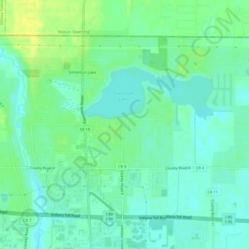
Name: Topografische Karte Simonton Lake, Höhe, Relief.
Ort: Simonton Lake, Elkhart County, Indiana, United States (41.73135 -85.99580 41.76018 -85.94216)
Durchschnittliche Höhe: 239 m
Minimale Höhe: 231 m
Maximale Höhe: 251 m
Andere topografische Karten
Klicken Sie auf eine Karte, um ihre Topografie, ihre Höhe und ihr Relief anzuzeigen.
Wakarusa
United States > Indiana > Elkhart County
Wakarusa, Elkhart County, Indiana, 46573, United States
Durchschnittliche Höhe: 257 m
Dunlap
United States > Indiana > Elkhart County
Dunlap, Elkhart County, Indiana, United States
Durchschnittliche Höhe: 239 m
Benton
United States > Indiana > Elkhart County
Benton, Elkhart County, Indiana, United States
Durchschnittliche Höhe: 257 m
Vistula
United States > Indiana > Elkhart County
Vistula, Elkhart County, Indiana, United States
Durchschnittliche Höhe: 243 m
Nappanee
United States > Indiana > Elkhart County
Nappanee, Elkhart County, Indiana, 46550, United States
Durchschnittliche Höhe: 261 m
Goshen
United States > Indiana > Elkhart County
Goshen, Elkhart County, Indiana, United States
Durchschnittliche Höhe: 252 m
New Paris
United States > Indiana > Elkhart County
New Paris, Elkhart County, Indiana, United States
Durchschnittliche Höhe: 251 m
Middlebury
United States > Indiana > Elkhart County
Middlebury, Elkhart County, Indiana, United States
Durchschnittliche Höhe: 266 m
Elkhart
United States > Indiana > Elkhart County
Elkhart, Elkhart County, Indiana, United States
Durchschnittliche Höhe: 235 m
Bristol
United States > Indiana > Elkhart County
Bristol, Elkhart County, Indiana, 46507, United States
Durchschnittliche Höhe: 237 m
Elkhart
United States > Indiana > Elkhart County > Elkhart
Elkhart, Elkhart County, Indiana, 46515, United States
Durchschnittliche Höhe: 247 m