
Topografische Karte Houx
Interaktive Karte
Klicken Sie auf die Karte, um die Höhe anzuzeigen.
Über diese Karte
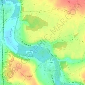
Name: Topografische Karte Houx, Höhe, Relief.
Durchschnittliche Höhe: 125 m
Minimale Höhe: 97 m
Maximale Höhe: 156 m
Andere topografische Karten
Klicken Sie auf eine Karte, um ihre Topografie, ihre Höhe und ihr Relief anzuzeigen.
Bonneval
France > Centre-Val de Loire > Eure-et-Loir
Bonneval, Châteaudun, Eure-et-Loir, Centre-Val de Loire, France métropolitaine, 28800, France
Durchschnittliche Höhe: 140 m
Saussay
France > Centre-Val de Loire > Eure-et-Loir
Saussay, Dreux, Eure-et-Loir, Centre-Val de Loire, France métropolitaine, 28260, France
Durchschnittliche Höhe: 80 m
Miermaigne
France > Centre-Val de Loire > Eure-et-Loir
Miermaigne, Nogent-le-Rotrou, Eure-et-Loir, Centre-Val de Loire, France métropolitaine, 28480, France
Durchschnittliche Höhe: 235 m
Laons
France > Centre-Val de Loire > Eure-et-Loir
Laons, Dreux, Eure-et-Loir, Centre-Val de Loire, France métropolitaine, 28270, France
Durchschnittliche Höhe: 170 m
Le Bois Corbières
France > Centre-Val de Loire > Eure-et-Loir > Bouglainval > Le Grand Gland
Le Bois Corbières, Le Grand Gland, Bouglainval, Chartres, Eure-et-Loir, Centre-Val de Loire, France métropolitaine, 28130, France
Durchschnittliche Höhe: 157 m
Ouerre
France > Centre-Val de Loire > Eure-et-Loir > Ouerre
Ouerre, Dreux, Eure-et-Loir, Centre-Val de Loire, France métropolitaine, 28500, France
Durchschnittliche Höhe: 121 m
Maison Forestière de la Grande Noé
France > Centre-Val de Loire > Eure-et-Loir > Châteauneuf-en-Thymerais > Maison Forestière de la Grande Noé
Maison Forestière de la Grande Noé, Châteauneuf-en-Thymerais, Dreux, Eure-et-Loir, Centre-Val de Loire, France métropolitaine, 28170, France
Durchschnittliche Höhe: 204 m
Chaudon
France > Centre-Val de Loire > Eure-et-Loir > Chaudon
Chaudon, Dreux, Eure-et-Loir, Centre-Val de Loire, France métropolitaine, 28210, France
Durchschnittliche Höhe: 119 m