
Topografische Karte Burlington
Interaktive Karte
Klicken Sie auf die Karte, um die Höhe anzuzeigen.
Über diese Karte
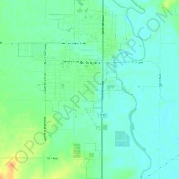
Name: Topografische Karte Burlington, Höhe, Relief.
Ort: Burlington, Coffey County, Kansas, United States (38.16503 -95.76789 38.21012 -95.73026)
Durchschnittliche Höhe: 315 m
Minimale Höhe: 304 m
Maximale Höhe: 340 m
Andere topografische Karten
Klicken Sie auf eine Karte, um ihre Topografie, ihre Höhe und ihr Relief anzuzeigen.
Gridley
United States > Kansas > Coffey County
Gridley, Coffey County, Kansas, United States
Durchschnittliche Höhe: 350 m
Lebo
United States > Kansas > Coffey County
Lebo, Coffey County, Kansas, United States
Durchschnittliche Höhe: 351 m
New Strawn
United States > Kansas > Coffey County
New Strawn, Coffey County, Kansas, United States
Durchschnittliche Höhe: 336 m
Waverly
United States > Kansas > Coffey County
Waverly, Coffey County, Kansas, United States
Durchschnittliche Höhe: 344 m
LeRoy
United States > Kansas > Coffey County
LeRoy, Coffey County, Kansas, 66857, United States
Durchschnittliche Höhe: 306 m