Geolokalisieren
👉 Easily get elevation data in JSON, GeoTIFF and KML formats using Elevation API
Vielen Dank für die Unterstützung dieser Website ❤️
Spenden

Topografische Karte Catcliffe

Klicken Sie auf die Karte, um die Höhe anzuzeigen.

👉 Easily get elevation data in JSON, GeoTIFF and KML formats using Elevation API
Vielen Dank für die Unterstützung dieser Website ❤️
Spenden

Catcliffe

The Catcliffe Glass Cone, part of the previous William Fenney's glassworks, is on Main Street. The centre of the village is dominated by a nine-arch viaduct that was built in 1901 to carry the Sheffield District Railway across the River Rother. Catcliffe Flash, to the south of the village, is a local nature reserve that is made up of a lake and marshland formed as the elevation of the land beside the River Rother dropped due to coal mining subsidence.

Wikipedia (CC-BY-SA 3.0)

👉 Easily get elevation data in JSON, GeoTIFF and KML formats using Elevation API
Vielen Dank für die Unterstützung dieser Website ❤️
Spenden

Über diese Karte

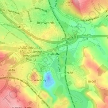
Name: Topografische Karte Catcliffe, Höhe, Relief.

Ort: Catcliffe, Rotherham, South Yorkshire, England, S60 5SS, United Kingdom (53.37227 -1.38269 53.41227 -1.34269)

Durchschnittliche Höhe: 58 m

Minimale Höhe: -38 m

Maximale Höhe: 123 m

👉 Easily get elevation data in JSON, GeoTIFF and KML formats using Elevation API
Vielen Dank für die Unterstützung dieser Website ❤️
Spenden

Andere topografische Karten

Klicken Sie auf eine Karte, um ihre Topografie, ihre Höhe und ihr Relief anzuzeigen.

Thrybergh

United Kingdom > England > Rotherham

Durchschnittliche Höhe: 48 m

Wickersley

United Kingdom > England > Rotherham

Durchschnittliche Höhe: 116 m

Hooton Roberts

United Kingdom > England > Rotherham > Hooton Roberts

Durchschnittliche Höhe: 51 m

Thurcroft

United Kingdom > England > Rotherham

Durchschnittliche Höhe: 111 m

Vielen Dank für die Unterstützung dieser Website ❤️
Spenden

Ulley

United Kingdom > England > Rotherham

Durchschnittliche Höhe: 92 m

Hellaby

United Kingdom > England > Rotherham

With a Dutch impression that was influenced by the style common in the colonies, the Hall was built on a hill and hence an extra storey was required to obtain the height at the front elevation.

Durchschnittliche Höhe: 113 m

Walkworth Wood

United Kingdom > England > Rotherham

Durchschnittliche Höhe: 99 m

Thorpe Salvin

United Kingdom > England > Rotherham

Thorpe Salvin is a village and a civil parish in the Metropolitan Borough of Rotherham in South Yorkshire, England, on the border with Nottinghamshire. It lies between Worksop and Harthill, and is located at an elevation of around 110 metres above sea level. At the 2011 Census, it had a population of 476, down…

Durchschnittliche Höhe: 102 m

Vielen Dank für die Unterstützung dieser Website ❤️
Spenden

Firbeck

United Kingdom > England > Rotherham

Durchschnittliche Höhe: 62 m

Wentworth

United Kingdom > England > Rotherham

Durchschnittliche Höhe: 96 m

Woodsetts

United Kingdom > England > Rotherham

Woodsetts is a village and civil parish in the Metropolitan Borough of Rotherham in South Yorkshire, England, on the border with Nottinghamshire. It lies between the towns of Dinnington and Worksop at an elevation of around 60 metres above sea level, and has a population of 1,746 at the 2011 Census. The…

Durchschnittliche Höhe: 70 m

Waverley

United Kingdom > England > Rotherham

Durchschnittliche Höhe: 58 m

Vielen Dank für die Unterstützung dieser Website ❤️
Spenden

Orgreave

United Kingdom > England > Rotherham

Durchschnittliche Höhe: 57 m

Bramley

United Kingdom > England > Rotherham

Durchschnittliche Höhe: 122 m

Ravenfield

United Kingdom > England > Rotherham

Durchschnittliche Höhe: 86 m

Dalton

United Kingdom > England > Rotherham > Dalton Magna

Durchschnittliche Höhe: 100 m

Vielen Dank für die Unterstützung dieser Website ❤️
Spenden

Anston Stones Wood

United Kingdom > England > Rotherham > North Anston

Durchschnittliche Höhe: 102 m

Todwick

United Kingdom > England > Rotherham > Todwick

Durchschnittliche Höhe: 105 m

Brampton Bierlow

United Kingdom > England > Rotherham > Brampton

Durchschnittliche Höhe: 55 m

Vielen Dank für die Unterstützung dieser Website ❤️
Spenden