
Topografische Karte Vojenský obvod Záhorie
Interaktive Karte
Klicken Sie auf die Karte, um die Höhe anzuzeigen.
Über diese Karte
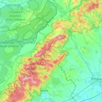
Name: Topografische Karte Vojenský obvod Záhorie, Höhe, Relief.
Durchschnittliche Höhe: 265 m
Minimale Höhe: 132 m
Maximale Höhe: 745 m
Andere topografische Karten
Klicken Sie auf eine Karte, um ihre Topografie, ihre Höhe und ihr Relief anzuzeigen.
Malacky
Slovakia > Region of Bratislava > District of Malacky
Malacky, District of Malacky, Region of Bratislava, Slovakia
Durchschnittliche Höhe: 168 m
Borinka
Slovakia > Region of Bratislava > District of Malacky > Borinka
Borinka, District of Malacky, Region of Bratislava, Slovakia
Durchschnittliche Höhe: 304 m
Three crosses
Slovakia > Region of Bratislava > District of Malacky > Pernek
Three crosses, Pernek, District of Malacky, Region of Bratislava, 900 53, Slovakia
Durchschnittliche Höhe: 335 m