
Spenden
Topografische Karte Obidowa
Klicken Sie auf die Karte, um die Höhe anzuzeigen.
Spenden
Obidowa
The summit of Turbacz has a subarctic climate (Köppen Dfc) due to its elevation. The average temperatures are comparable with those found in places in far Northern Europe, such as Alta, Norway, however, the high annual precipitation in combination with the low temperatures places it firmly within the Subalpine Rainforest zone according to Holdridge.
Spenden
Über diese Karte
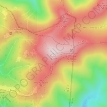
Name: Topografische Karte Obidowa, Höhe, Relief.
Durchschnittliche Höhe: 1.117 m
Minimale Höhe: 861 m
Maximale Höhe: 1.301 m
Spenden
Andere topografische Karten
Klicken Sie auf eine Karte, um ihre Topografie, ihre Höhe und ihr Relief anzuzeigen.
Nowy Targ
Poland > Lesser Poland Voivodeship > Nowy Targ County
Nowy Targ is located in the heart of Podhale (one of the Goral Lands) at the altitude of 585–850 m above sea level (AMSL); latitude 49°28' N, longitude 20°01' E. Distance to the main urban agglomerations in Poland is: Warsaw – 376 km (234 mi), Łódź – 348 km (216 mi), Kraków – 84 km (52 mi),…
Durchschnittliche Höhe: 679 m
Puścizna Wielka
Poland > Lesser Poland Voivodeship > Nowy Targ County > Piekielnik
Durchschnittliche Höhe: 660 m
Spenden
Nowy Targ
Poland > Lesser Poland Voivodeship > Nowy Targ County > Nowy Targ
Nowy Targ is located in the heart of Podhale (one of the Goral Lands) at the altitude of 585–850 m above sea level (AMSL); latitude 49°28' N, longitude 20°01' E. Distance to the main urban agglomerations in Poland is: Warsaw – 376 km (234 mi), Łódź – 348 km (216 mi), Kraków – 84 km (52 mi),…
Durchschnittliche Höhe: 676 m
Spenden
Maniowy
Poland > Lesser Poland Voivodeship > Nowy Targ County
Located on the southern slopes of the Gorce Mountains, new Maniowy was built in 1970-1980s after having been moved to a higher altitude, from an area upon which Lake Czorsztyn now stretches. The history of the old village reached back to at least 1326 when it was founded during the colonisation of the Podhale…
Durchschnittliche Höhe: 677 m
Spenden
Lake Czorsztyn
Poland > Lesser Poland Voivodeship > Nowy Targ County > Maniowy
Durchschnittliche Höhe: 616 m
Spenden
Sromowce Niżne
Poland > Lesser Poland Voivodeship > Nowy Targ County > Sromowce Niżne
Durchschnittliche Höhe: 587 m
Spenden