
Topografische Karte Cornan West
Interaktive Karte
Klicken Sie auf die Karte, um die Höhe anzuzeigen.
Über diese Karte
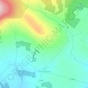
Name: Topografische Karte Cornan West, Höhe, Relief.
Durchschnittliche Höhe: 258 m
Minimale Höhe: 174 m
Maximale Höhe: 469 m
Andere topografische Karten
Klicken Sie auf eine Karte, um ihre Topografie, ihre Höhe und ihr Relief anzuzeigen.
The Municipal District of Wicklow
The Municipal District of Wicklow, County Wicklow, Leinster, Irlande
Durchschnittliche Höhe: 263 m
Enniskerry
Enniskerry, County Wicklow, Leinster, Irlande
Durchschnittliche Höhe: 111 m
Glendalough
Glendalough, The Municipal District of Wicklow, County Wicklow, Leinster, A98 VY72, Irlande
Durchschnittliche Höhe: 284 m
Blessington
Blessington, County Wicklow, Leinster, Irlande
Durchschnittliche Höhe: 205 m
Enniskerry
Enniskerry, Enniskerry ED, The Municipal District of Bray, County Wicklow, Leinster, Irlande
Durchschnittliche Höhe: 104 m
Blessington
Irlande > County Wicklow > Blessington
Blessington, The Municipal District of Baltinglass, County Wicklow, Leinster, W91 AC86, Irlande
Durchschnittliche Höhe: 223 m