
Topografische Karte San Antonio
Interaktive Karte
Klicken Sie auf die Karte, um die Höhe anzuzeigen.
Über diese Karte
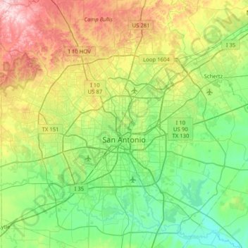
Name: Topografische Karte San Antonio, Höhe, Relief.
Ort: San Antonio, Bexar County, Texas, United States (29.18626 -98.81319 29.73096 -98.22300)
Durchschnittliche Höhe: 247 m
Minimale Höhe: 117 m
Maximale Höhe: 575 m
San Antonio is approximately 75 miles (121 km) to the southwest of its neighboring city, Austin, the state capital, about 190 miles (310 km) west of Houston, and about 250 miles (400 km) south of the Dallas–Fort Worth area. The city has a total area of 465.4 square miles (1,205.4 km2); 460.93 square miles (1,193.8 km2) of San Antonio's total area is land and 4.5 square miles (11.7 km2) of it is water.[43] The city's gently rolling terrain is dotted with oak trees, forested land, mesquite, and cacti. The Texas Hill Country reaches into the far northern portions of the city. San Antonio sits on the Balcones Escarpment. Its altitude is approximately 662 feet (202 m) above sea level.[44]
Andere topografische Karten
Klicken Sie auf eine Karte, um ihre Topografie, ihre Höhe und ihr Relief anzuzeigen.
Leon Valley
United States > Texas > Bexar County
Leon Valley, Bexar County, Texas, United States
Durchschnittliche Höhe: 260 m
Windcrest
United States > Texas > Bexar County
Windcrest, Bexar County, Texas, United States
Durchschnittliche Höhe: 240 m
Live Oak
United States > Texas > Bexar County
Live Oak, Bexar County, Texas, United States
Durchschnittliche Höhe: 262 m