
Topografische Karte Mountain Ranch
Klicken Sie auf die Karte, um die Höhe anzuzeigen.
Über diese Karte
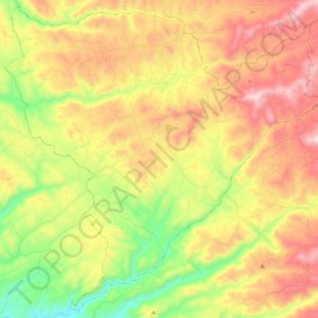
Name: Topografische Karte Mountain Ranch, Höhe, Relief.
Durchschnittliche Höhe: 733 m
Minimale Höhe: 358 m
Maximale Höhe: 1.140 m
Andere topografische Karten
Klicken Sie auf eine Karte, um ihre Topografie, ihre Höhe und ihr Relief anzuzeigen.
Murphys
United States > California > Calaveras County
"MURPHY'S CAMP is a curious old mining-town in Calaveras County, at an elevation of 2,400 feet (730 m) above the sea, situated like a nest in the center of a rough, gravelly region, rich in gold. Granites, slates, lavas, limestone, iron ores, quartz veins, auriferous gravels, remnants of dead fire-rivers and…
Durchschnittliche Höhe: 702 m
Dorrington
United States > California > Calaveras County
According to the United States Census Bureau, the CDP has a total area of 3.7 square miles (9.6 km2), 99.86% of it land. The elevation is 4,800 feet ASL.
Durchschnittliche Höhe: 1.464 m
Blue Lake Springs
United States > California > Calaveras County > Blue Lake Springs
Durchschnittliche Höhe: 1.312 m
Dorrington
United States > California > Calaveras County
According to the United States Census Bureau, the CDP has a total area of 3.7 square miles (9.6 km2), 99.86% of it land. The elevation is 4,800 feet ASL.
Durchschnittliche Höhe: 1.464 m
Murphys
United States > California > Calaveras County > Murphys
"MURPHY'S CAMP is a curious old mining-town in Calaveras County, at an elevation of 2,400 feet (730 m) above the sea, situated like a nest in the center of a rough, gravelly region, rich in gold. Granites, slates, lavas, limestone, iron ores, quartz veins, auriferous gravels, remnants of dead fire-rivers and…
Durchschnittliche Höhe: 702 m